
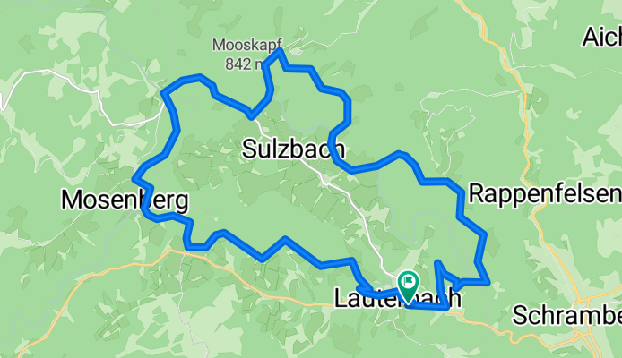
Lauterbach-Sulzbach-Fohrenbühl-Lauterbach
A cycling route starting in Lauterbach/Schwarzwald, Baden-Württemberg, Germany.
Overview
About this route
Mountainbikestrecke mit Abwechslung und schönen Aussichtspunkten. Teilweise anspruchsvoll und bestimmt nicht langweilig.
- -:--
- Duration
- 22.4 km
- Distance
- 784 m
- Ascent
- 763 m
- Descent
- ---
- Avg. speed
- 844 m
- Max. altitude
Route quality
Waytypes & surfaces along the route
Waytypes
Quiet road
10.9 km
(49 %)
Track
6 km
(27 %)
Surfaces
Paved
8.3 km
(37 %)
Unpaved
5.2 km
(23 %)
Asphalt
8.3 km
(37 %)
Gravel
3.4 km
(15 %)
Continue with Bikemap
Use, edit, or download this cycling route
You would like to ride Lauterbach-Sulzbach-Fohrenbühl-Lauterbach or customize it for your own trip? Here is what you can do with this Bikemap route:
Free features
- Save this route as favorite or in collections
- Copy & plan your own version of this route
- Sync your route with Garmin or Wahoo
Premium features
Free trial for 3 days, or one-time payment. More about Bikemap Premium.
- Navigate this route on iOS & Android
- Export a GPX / KML file of this route
- Create your custom printout (try it for free)
- Download this route for offline navigation
Discover more Premium features.
Get Bikemap PremiumFrom our community
Other popular routes starting in Lauterbach/Schwarzwald
 kleine Trainingsrunde
- Distance
- 13.6 km
- Ascent
- 667 m
- Descent
- 667 m
- Location
- Lauterbach/Schwarzwald, Baden-Württemberg, Germany
 MTB TOUR Leicht
- Distance
- 33.1 km
- Ascent
- 666 m
- Descent
- 663 m
- Location
- Lauterbach/Schwarzwald, Baden-Württemberg, Germany
 10.01.2018
- Distance
- 32.9 km
- Ascent
- 723 m
- Descent
- 789 m
- Location
- Lauterbach/Schwarzwald, Baden-Württemberg, Germany
 20130824_Hornbergrunde_Bärenfelsen_O-trail_mit_Manuel_im_Regen
- Distance
- 35.8 km
- Ascent
- 1,072 m
- Descent
- 1,073 m
- Location
- Lauterbach/Schwarzwald, Baden-Württemberg, Germany
 MTB TOUR Normal
- Distance
- 37.5 km
- Ascent
- 660 m
- Descent
- 664 m
- Location
- Lauterbach/Schwarzwald, Baden-Württemberg, Germany
 Lauterbach-Sulzbach-Fohrenbühl
- Distance
- 33 km
- Ascent
- 1,063 m
- Descent
- 1,063 m
- Location
- Lauterbach/Schwarzwald, Baden-Württemberg, Germany
 MTB TOUR sehr leicht
- Distance
- 24.9 km
- Ascent
- 496 m
- Descent
- 500 m
- Location
- Lauterbach/Schwarzwald, Baden-Württemberg, Germany
 Fohrenbüul-Halbmeil-Wolfach-Hausach-Hornberg-Reichenbach-Langenschiltach-Tennenbronn-Eichbach Lauterbach
- Distance
- 58.5 km
- Ascent
- 1,080 m
- Descent
- 1,080 m
- Location
- Lauterbach/Schwarzwald, Baden-Württemberg, Germany
Open it in the app