

Po hrebeni Levočských vrchov
A cycling route starting in Kežmarok, Prešov Region, Slovakia.
Overview
About this route
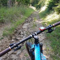
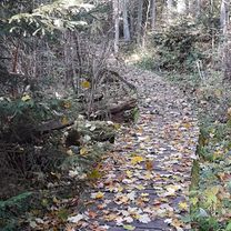
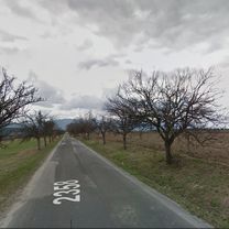
The route starts in the town of Kežmarok and continues toward Ľubica and Záľubica, where it enters the former military district of Javorina (VOJ). Just past the barrier, we turn right toward the abandoned village of Ruskinovce. From Ruskinovce, we go straight and, through smaller switchbacks, reach the saddle below Krížový Peak, where we turn left and continue on a gravel road. After several hundred meters, we begin the ascent to Krížový Peak. We pass the former tourist hut Sklenár and after a while arrive at the hut Gehuľa, from where we go straight and descend into an area called Nad Peklom. Later, we reach the monument, at which point we turn left and continue on the asphalt road toward the turn for Kamenna Dolina, where we do not turn into the valley but continue on past the hut Vinná and reach Václavák, where we take the second turn to the left. Following the broken asphalt road, we arrive at the Derežovská intersection where we turn left and descend on a long descent to the village of Ihľany. Here we again begin to climb slightly toward the interior of the military district and reach an intersection where we turn right and through Ľubické Kúpele reach Záľubice, then Ľubice, completing the loop back in Kežmarok.
- -:--
- Duration
- 57.9 km
- Distance
- 808 m
- Ascent
- 808 m
- Descent
- ---
- Avg. speed
- ---
- Max. altitude

Continue with Bikemap
Use, edit, or download this cycling route
You would like to ride Po hrebeni Levočských vrchov or customize it for your own trip? Here is what you can do with this Bikemap route:
Free features
- Save this route as favorite or in collections
- Copy & plan your own version of this route
- Sync your route with Garmin or Wahoo
Premium features
Free trial for 3 days, or one-time payment. More about Bikemap Premium.
- Navigate this route on iOS & Android
- Export a GPX / KML file of this route
- Create your custom printout (try it for free)
- Download this route for offline navigation
Discover more Premium features.
Get Bikemap PremiumFrom our community
Other popular routes starting in Kežmarok
 Tatranský okruh
- Distance
- 97.4 km
- Ascent
- 1,296 m
- Descent
- 1,220 m
- Location
- Kežmarok, Prešov Region, Slovakia
 Cez Hory, cez Lesy.
- Distance
- 32.2 km
- Ascent
- 572 m
- Descent
- 647 m
- Location
- Kežmarok, Prešov Region, Slovakia
 Lanškrounská 15 do Lanškrounská 13
- Distance
- 45.1 km
- Ascent
- 568 m
- Descent
- 626 m
- Location
- Kežmarok, Prešov Region, Slovakia
 Día 4. Kezmarok - Tatry - Liptovsky Mikulas
- Distance
- 82.1 km
- Ascent
- 738 m
- Descent
- 784 m
- Location
- Kežmarok, Prešov Region, Slovakia
 Lanškrounská 13 do Lanškrounská 15
- Distance
- 43.2 km
- Ascent
- 509 m
- Descent
- 454 m
- Location
- Kežmarok, Prešov Region, Slovakia
 Kežmarska cyklistická liga 1.kolo
- Distance
- 70.4 km
- Ascent
- 856 m
- Descent
- 945 m
- Location
- Kežmarok, Prešov Region, Slovakia
 Lanškrounská 15 do Lanškrounská 15
- Distance
- 48 km
- Ascent
- 1,242 m
- Descent
- 1,279 m
- Location
- Kežmarok, Prešov Region, Slovakia
 Po hrebeni Levočských vrchov
- Distance
- 57.9 km
- Ascent
- 808 m
- Descent
- 808 m
- Location
- Kežmarok, Prešov Region, Slovakia
Open it in the app