

MTB_ZUR_Arbeit_FiBa_Schmandkopf!_Hinterlandswaldstr_StephHau
A cycling route starting in Bad Schwalbach, Hesse, Germany.
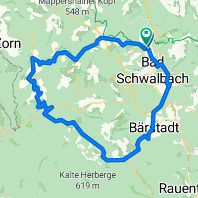
Overview
About this route
Über FiBa hoch zum Schmandkopf! über Hinterlandswaldstr. auf Hohe Straße unter Mappen Richtung grauer Stein nach Stephanshausen...Johannisberg: Juli
- -:--
- Duration
- 25 km
- Distance
- 428 m
- Ascent
- 774 m
- Descent
- ---
- Avg. speed
- ---
- Max. altitude

Route quality
Waytypes & surfaces along the route
Waytypes
Track
11.9 km
(47 %)
Quiet road
6.4 km
(25 %)
Surfaces
Paved
12.4 km
(49 %)
Unpaved
7.4 km
(30 %)
Asphalt
11.6 km
(46 %)
Gravel
6.9 km
(28 %)
Continue with Bikemap
Use, edit, or download this cycling route
You would like to ride MTB_ZUR_Arbeit_FiBa_Schmandkopf!_Hinterlandswaldstr_StephHau or customize it for your own trip? Here is what you can do with this Bikemap route:
Free features
- Save this route as favorite or in collections
- Copy & plan your own version of this route
- Sync your route with Garmin or Wahoo
Premium features
Free trial for 3 days, or one-time payment. More about Bikemap Premium.
- Navigate this route on iOS & Android
- Export a GPX / KML file of this route
- Create your custom printout (try it for free)
- Download this route for offline navigation
Discover more Premium features.
Get Bikemap PremiumFrom our community
Other popular routes starting in Bad Schwalbach
 SWA-RAM-Fsh-Bär-SWA
- Distance
- 20.5 km
- Ascent
- 471 m
- Descent
- 488 m
- Location
- Bad Schwalbach, Hesse, Germany
 🪅...⁉️
- Distance
- 44.7 km
- Ascent
- 1,059 m
- Descent
- 1,059 m
- Location
- Bad Schwalbach, Hesse, Germany
 Adolfseck - Orlen 10 km Limesradweg
- Distance
- 10 km
- Ascent
- 274 m
- Descent
- 150 m
- Location
- Bad Schwalbach, Hesse, Germany
 Bad Schwalbach - gr Feldberg
- Distance
- 42.3 km
- Ascent
- 772 m
- Descent
- 552 m
- Location
- Bad Schwalbach, Hesse, Germany
 Born_Neuhof_Born
- Distance
- 22.3 km
- Ascent
- 289 m
- Descent
- 289 m
- Location
- Bad Schwalbach, Hesse, Germany
 Lindschied - Bärstadt - Wisper
- Distance
- 40.2 km
- Ascent
- 733 m
- Descent
- 735 m
- Location
- Bad Schwalbach, Hesse, Germany
 MTB_ZUR_Arbeit_FiBa_Oglad_Mappen_SteHau_JohBe
- Distance
- 24.5 km
- Ascent
- 378 m
- Descent
- 724 m
- Location
- Bad Schwalbach, Hesse, Germany
 Ramschied - Espenschied - Zorn - Reckenroth - Diez - Bad Schwalbach - Ramschied
- Distance
- 92.9 km
- Ascent
- 1,468 m
- Descent
- 1,541 m
- Location
- Bad Schwalbach, Hesse, Germany
Open it in the app