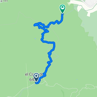
De Carretera de Olzinelles, San Celoni a Avenida de la Paz, 79, San Celoni
A cycling route starting in Vallgorguina, Catalonia, Spain.
Overview
About this route
- 1 h 51 min
- Duration
- 20.8 km
- Distance
- 514 m
- Ascent
- 569 m
- Descent
- 11.2 km/h
- Avg. speed
- ---
- Avg. speed
Route quality
Waytypes & surfaces along the route
Waytypes
Track
8.2 km
(40 %)
Road
6.4 km
(31 %)
Surfaces
Paved
9.9 km
(48 %)
Unpaved
7.3 km
(35 %)
Asphalt
7 km
(33 %)
Unpaved (undefined)
3.4 km
(16 %)
Continue with Bikemap
Use, edit, or download this cycling route
You would like to ride De Carretera de Olzinelles, San Celoni a Avenida de la Paz, 79, San Celoni or customize it for your own trip? Here is what you can do with this Bikemap route:
Free features
- Save this route as favorite or in collections
- Copy & plan your own version of this route
- Sync your route with Garmin or Wahoo
Premium features
Free trial for 3 days, or one-time payment. More about Bikemap Premium.
- Navigate this route on iOS & Android
- Export a GPX / KML file of this route
- Create your custom printout (try it for free)
- Download this route for offline navigation
Discover more Premium features.
Get Bikemap PremiumFrom our community
Other popular routes starting in Vallgorguina
- VALLGORGUINA - CAN RUTI
- Distance
- 44.3 km
- Ascent
- 1,357 m
- Descent
- 1,377 m
- Location
- Vallgorguina, Catalonia, Spain
- CORREDOR
- Distance
- 28.4 km
- Ascent
- 320 m
- Descent
- 633 m
- Location
- Vallgorguina, Catalonia, Spain
- Pedalada de Vallgourgina 2010
- Distance
- 38.7 km
- Ascent
- 907 m
- Descent
- 907 m
- Location
- Vallgorguina, Catalonia, Spain
- Conrrería - Argentona - Collet - Cànovas - Vilamajor - St. Esteve - St. Celoni
- Distance
- 113 km
- Ascent
- 916 m
- Descent
- 914 m
- Location
- Vallgorguina, Catalonia, Spain
- Bikegorguina 2012
- Distance
- 31 km
- Ascent
- 754 m
- Descent
- 752 m
- Location
- Vallgorguina, Catalonia, Spain
- S Halloween
- Distance
- 60.5 km
- Ascent
- 1,050 m
- Descent
- 1,050 m
- Location
- Vallgorguina, Catalonia, Spain
- Montnegre ARG Recon
- Distance
- 33 km
- Ascent
- 621 m
- Descent
- 819 m
- Location
- Vallgorguina, Catalonia, Spain
- Caldetes-Olzinelles BTT
- Distance
- 50.8 km
- Ascent
- 1,257 m
- Descent
- 1,256 m
- Location
- Vallgorguina, Catalonia, Spain
Open it in the app