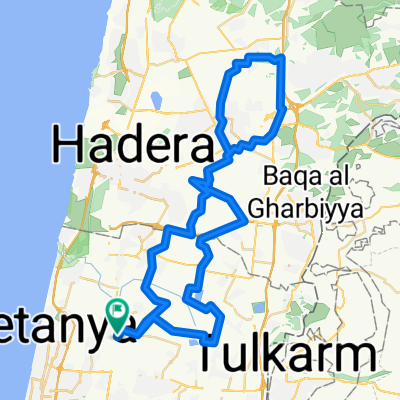
ארומה סטייג' רופין 4 שעות מישורים on GPSies.com
A cycling route starting in Bet Yiẕẖaq, Central District, Israel.
Overview
About this route
מסלול של 75 ק"מ שנוסע מארומה רופין, דרך בית הלוי לכיוון עין שמר ושביל המוביל, משם סינגלים בשטח המהמם של גליקסון וחזרה דרך גבעת חיים, נחל אלכסנדר וחזרה לבית הלווי ולארומה. שימו לב בקילומטר 4.5 יש שמאלה במעבר צר בין משאבת מים לברוש. כו כן, יש קצת חציות כביש אז בבקשה בזהירות. אימון נעים ובהצלחה לכולם!
- 7 h 25 min
- Duration
- 74.1 km
- Distance
- 487 m
- Ascent
- 487 m
- Descent
- 10 km/h
- Avg. speed
- ---
- Max. altitude
Continue with Bikemap
Use, edit, or download this cycling route
You would like to ride ארומה סטייג' רופין 4 שעות מישורים on GPSies.com or customize it for your own trip? Here is what you can do with this Bikemap route:
Free features
- Save this route as favorite or in collections
- Copy & plan your own version of this route
- Sync your route with Garmin or Wahoo
Premium features
Free trial for 3 days, or one-time payment. More about Bikemap Premium.
- Navigate this route on iOS & Android
- Export a GPX / KML file of this route
- Create your custom printout (try it for free)
- Download this route for offline navigation
Discover more Premium features.
Get Bikemap PremiumFrom our community
Other popular routes starting in Bet Yiẕẖaq
- HaOgen Street 100 to HaOgen Street 100
- Distance
- 9.1 km
- Ascent
- 56 m
- Descent
- 76 m
- Location
- Bet Yiẕẖaq, Central District, Israel
- Haogen to Bat Hefer and back
- Distance
- 31.5 km
- Ascent
- 609 m
- Descent
- 614 m
- Location
- Bet Yiẕẖaq, Central District, Israel
- HaOgen Street 100 to HaOgen Street 100
- Distance
- 16.3 km
- Ascent
- 82 m
- Descent
- 103 m
- Location
- Bet Yiẕẖaq, Central District, Israel
- Moderate route
- Distance
- 21.9 km
- Ascent
- 244 m
- Descent
- 257 m
- Location
- Bet Yiẕẖaq, Central District, Israel
- ארומה סטייג' רופין 4 שעות מישורים on GPSies.com
- Distance
- 74.1 km
- Ascent
- 487 m
- Descent
- 487 m
- Location
- Bet Yiẕẖaq, Central District, Israel
- נודרופ - מעברות , חדרה, קציר, חריש , כלניות הרואה
- Distance
- 83.3 km
- Ascent
- 472 m
- Descent
- 476 m
- Location
- Bet Yiẕẖaq, Central District, Israel
- omer pt3
- Distance
- 26.3 km
- Ascent
- 444 m
- Descent
- 414 m
- Location
- Bet Yiẕẖaq, Central District, Israel
- HaOgen Street 100 to HaOgen Street 100
- Distance
- 14.2 km
- Ascent
- 61 m
- Descent
- 86 m
- Location
- Bet Yiẕẖaq, Central District, Israel
Open it in the app