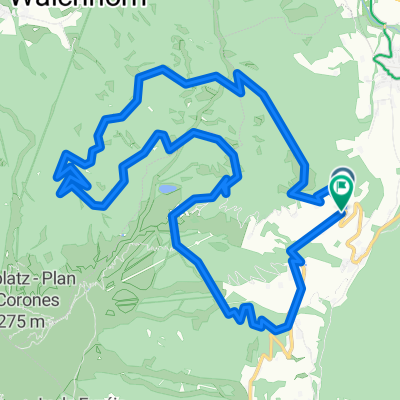
3 Almen
A cycling route starting in Olang, Trentino-Alto Adige, Italy.
Overview
About this route
- -:--
- Duration
- 26.8 km
- Distance
- 1,620 m
- Ascent
- 1,620 m
- Descent
- ---
- Avg. speed
- ---
- Max. altitude
Route quality
Waytypes & surfaces along the route
Waytypes
Track
20.9 km
(78 %)
Path
3.5 km
(13 %)
Quiet road
2.4 km
(9 %)
Surfaces
Paved
5.6 km
(21 %)
Unpaved
19 km
(71 %)
Gravel
16.9 km
(63 %)
Asphalt
5.6 km
(21 %)
Continue with Bikemap
Use, edit, or download this cycling route
You would like to ride 3 Almen or customize it for your own trip? Here is what you can do with this Bikemap route:
Free features
- Save this route as favorite or in collections
- Copy & plan your own version of this route
- Sync your route with Garmin or Wahoo
Premium features
Free trial for 3 days, or one-time payment. More about Bikemap Premium.
- Navigate this route on iOS & Android
- Export a GPX / KML file of this route
- Create your custom printout (try it for free)
- Download this route for offline navigation
Discover more Premium features.
Get Bikemap PremiumFrom our community
Other popular routes starting in Olang
Olang / Valdadora - Bormio (BH)- Distance
- 297 km
- Ascent
- 6,225 m
- Descent
- 6,053 m
- Location
- Olang, Trentino-Alto Adige, Italy
Via Pracken, Valdaora to Via Furcia, Valdaora- Distance
- 9.7 km
- Ascent
- 540 m
- Descent
- 598 m
- Location
- Olang, Trentino-Alto Adige, Italy
Kronplatz-Tour (Olang - Kronplatz)- Distance
- 14.7 km
- Ascent
- 1,277 m
- Descent
- 55 m
- Location
- Olang, Trentino-Alto Adige, Italy
Via Hans Von Perthaler 8a nach St.Veit- Distance
- 19.5 km
- Ascent
- 717 m
- Descent
- 236 m
- Location
- Olang, Trentino-Alto Adige, Italy
Route nach Via Polo Stegona Marco- Distance
- 14.8 km
- Ascent
- 48 m
- Descent
- 329 m
- Location
- Olang, Trentino-Alto Adige, Italy
Staller Sattel- Distance
- 148.7 km
- Ascent
- 2,518 m
- Descent
- 2,424 m
- Location
- Olang, Trentino-Alto Adige, Italy
Antholzer Höhentour ab Olang- Distance
- 37 km
- Ascent
- 1,461 m
- Descent
- 1,181 m
- Location
- Olang, Trentino-Alto Adige, Italy
intorno il kronplatz- Distance
- 54.7 km
- Ascent
- 1,164 m
- Descent
- 1,164 m
- Location
- Olang, Trentino-Alto Adige, Italy
Open it in the app

