

Europaradweg R1 (D3) - Vom Harz zum Fläming!
A cycling route starting in Stapelburg, Saxony-Anhalt, Germany.
Overview
About this route
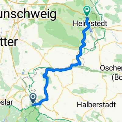
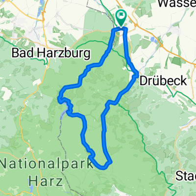
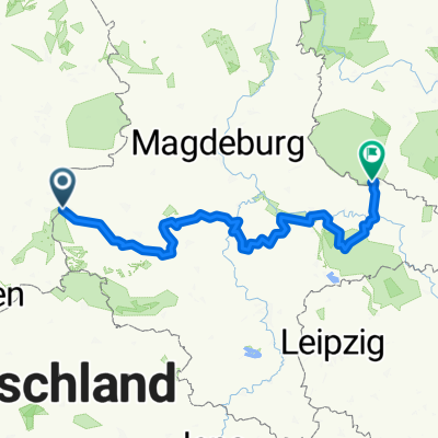
Erleben Sie die vielfältigen Landschaftsbilder vom Harz, über Anhalt bis in den Fläming sowie die Kulturdenkmäler entlang des Europaradweges R1 in Sachsen-Anhalt. Hier erwarten Sie über 260 km Radweg, auf dem Sie in fünf Tagesetappen vom Nationalpark-Ort Ilsenburg bis in die Lutherstadt Wittenberg zahlreiche Erlebnisse und Entdeckungen erwarten.
- -:--
- Duration
- 262.1 km
- Distance
- 1,521 m
- Ascent
- 1,606 m
- Descent
- ---
- Avg. speed
- ---
- Max. altitude
Route quality
Waytypes & surfaces along the route
Waytypes
Track
83.9 km
(32 %)
Quiet road
62.9 km
(24 %)
Surfaces
Paved
183.5 km
(70 %)
Unpaved
41.9 km
(16 %)
Asphalt
170.4 km
(65 %)
Gravel
36.7 km
(14 %)
Continue with Bikemap
Use, edit, or download this cycling route
You would like to ride Europaradweg R1 (D3) - Vom Harz zum Fläming! or customize it for your own trip? Here is what you can do with this Bikemap route:
Free features
- Save this route as favorite or in collections
- Copy & plan your own version of this route
- Split it into stages to create a multi-day tour
- Sync your route with Garmin or Wahoo
Premium features
Free trial for 3 days, or one-time payment. More about Bikemap Premium.
- Navigate this route on iOS & Android
- Export a GPX / KML file of this route
- Create your custom printout (try it for free)
- Download this route for offline navigation
Discover more Premium features.
Get Bikemap PremiumFrom our community
Other popular routes starting in Stapelburg
 1000 Höhenmeter am Stück "Brockentour"
- Distance
- 36.9 km
- Ascent
- 983 m
- Descent
- 985 m
- Location
- Stapelburg, Saxony-Anhalt, Germany
 Kurze Harztour
- Distance
- 32.5 km
- Ascent
- 659 m
- Descent
- 650 m
- Location
- Stapelburg, Saxony-Anhalt, Germany
 Harzrunde
- Distance
- 49.3 km
- Ascent
- 903 m
- Descent
- 903 m
- Location
- Stapelburg, Saxony-Anhalt, Germany
 D11: Stapelburg - Mariental
- Distance
- 70.4 km
- Ascent
- 476 m
- Descent
- 601 m
- Location
- Stapelburg, Saxony-Anhalt, Germany
 Brockenaufstieg
- Distance
- 18.2 km
- Ascent
- 997 m
- Descent
- 120 m
- Location
- Stapelburg, Saxony-Anhalt, Germany
 1000 Höhenmeter am Stück "Brockentour"
- Distance
- 36.9 km
- Ascent
- 1,047 m
- Descent
- 1,050 m
- Location
- Stapelburg, Saxony-Anhalt, Germany
 Harz: Eckertal - Osterwieck - Eckertal
- Distance
- 40.1 km
- Ascent
- 196 m
- Descent
- 196 m
- Location
- Stapelburg, Saxony-Anhalt, Germany
 Europaradweg R1 (D3) - Vom Harz zum Fläming!
- Distance
- 262.1 km
- Ascent
- 1,521 m
- Descent
- 1,606 m
- Location
- Stapelburg, Saxony-Anhalt, Germany
Open it in the app