

Faro Touring Tour
A cycling route starting in Faro, Faro District, Portugal.
Overview
About this route
EN:
About the route
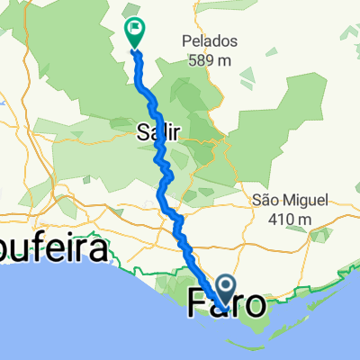
• Start and finish of the route: Faro (Praça Dom Francisco Gomes)
• Difficulty level: Easy
• Time needed: Approximately 3h00mins at an average of 12 km/h
• Elevation: Climb 386 m, 386 descent
• GPS Coordinates: 37.01614, -7.93537
• Distance: 38 km
Description
From the pleasure harbour in the city centre, start by riding through Faro’s historical old town. Once you reach the outskirts of the city the route takes you into the inland part of the municipality, through the village of Conceição and, farther on, Estoi. There are several interesting places to visit in Estoi, such as Ossónoba Square, located in the oldest part of town, the Estoi Palace Pousada, the Main Church and the ruins of the Milreu Roman Villa. As you go around the Guelhim Hill, you will encounter the little village of Santa Bárbara de Nexe, with its impressive Main Church.
The ride back to the capital of the municipality is mainly downhill and on flat terrain, taking you through the woodland area of Ludo.
PT:
Sobre a rota
Início e fim do percurso – Faro - Praça Dom Francisco Gomes
Grau/nível de dificuldade - Fácil
Tempo de duração – Aproximadamente 3h00 à média de cerca de 12,5km/h
Altimetria – 320mt de subida
Coordenadas GPS: 37.01614, -7.93537
Distância: 37.9km
Da doca de recreio de Faro, bem na baixa da cidade inicie a pedalada pelo centro histórico da cidade. Contornando a cidade, o percurso segue depois para o interior do concelho passando pela aldeia da Conceição e mais adiante por Estoi. Esta última oferece vários pontos de interesse que poderá visitar como o Largo Ossónoba, a Pousada do Palácio de Estoi, a Igreja Matriz ou as ruínas romanas do Milreu. Contornando o cerro do Guilhim, irá encontrar a pequena aldeia de Santa Bárbara de Nexe.
O retorno à capital do concelho é feito maioritariamente em descida e terreno plano passando pela área florestal do Ludo.
ES:
Sobre la ruta
• Inicio y final de la ruta: Faro (Praça Dom Francisco Gomes)
• Nivel de dificultad: Fácil
• Duración: Unas 3 horas a una media aproximada de 12,5 km/h
• Altimetría:
386 metros de ascensión
386 metros descenso
Coordenadas GPS: 37.01614, -7.93537
Distancia: 38 kilómetros
Descripción
La ruta parte del puerto deportivo de Faro hacia el centro histórico de la ciudad. Rodea el núcleo urbano y continúa hacia el interior del municipio, pasando por la aldea de Conceição y por Estoi. Esta última localidad cuenta con varios lugares de interés, como la plaza Ossónoba, ubicada en el núcleo residencial más antiguo, la posada del Palacio de Estoi, la iglesia matriz y las ruinas de la villa romana de Milreu. Bordeando el cerro de Guelhim, encontrará la pequeña aldea de Santa Bárbara de Nexe y su imponente iglesia matriz.
El regreso a la capital del municipio transcurre casi en su totalidad en bajada y terreno plano, y pasa por la zona forestal de Ludo.
- -:--
- Duration
- 38 km
- Distance
- 393 m
- Ascent
- 393 m
- Descent
- ---
- Avg. speed
- ---
- Max. altitude

Route quality
Waytypes & surfaces along the route
Waytypes
Quiet road
17.1 km
(45 %)
Road
12.5 km
(33 %)
Surfaces
Paved
8 km
(21 %)
Unpaved
5.7 km
(15 %)
Asphalt
8 km
(21 %)
Gravel
3.4 km
(9 %)
Route highlights
Points of interest along the route

Point of interest after 0.2 km
Arco da Vila

Point of interest after 0.4 km
Sé de Faro
Point of interest after 9.9 km
Conceição de Faro
Point of interest after 15.2 km
Palácio de Estoi
Point of interest after 15.5 km
Igreja Matriz de Estoi
Point of interest after 16.4 km
Ruínas Romanas de Milreu
Point of interest after 24.1 km
Santa Bárbara de Nexe
Point of interest after 26.4 km
Estádio do Algarve
Point of interest after 30 km
Zona florestal do Ludo

Point of interest after 36.4 km
Parque Ribeirinho
Continue with Bikemap
Use, edit, or download this cycling route
You would like to ride Faro Touring Tour or customize it for your own trip? Here is what you can do with this Bikemap route:
Free features
- Save this route as favorite or in collections
- Copy & plan your own version of this route
- Sync your route with Garmin or Wahoo
Premium features
Free trial for 3 days, or one-time payment. More about Bikemap Premium.
- Navigate this route on iOS & Android
- Export a GPX / KML file of this route
- Create your custom printout (try it for free)
- Download this route for offline navigation
Discover more Premium features.
Get Bikemap PremiumFrom our community
Other popular routes starting in Faro
 Faro - Almodôvar
- Distance
- 53 km
- Ascent
- 1,308 m
- Descent
- 837 m
- Location
- Faro, Faro District, Portugal
 Petite balade au Portugal
- Distance
- 429.1 km
- Ascent
- 1,117 m
- Descent
- 1,082 m
- Location
- Faro, Faro District, Portugal
 2009-05-16 - Ecovia Algarve (Vila Real de Santo Antonio-Faro)
- Distance
- 72.8 km
- Ascent
- 172 m
- Descent
- 170 m
- Location
- Faro, Faro District, Portugal
 Faro - Barcelona
- Distance
- 1,770.9 km
- Ascent
- 831 m
- Descent
- 782 m
- Location
- Faro, Faro District, Portugal
 Faro Quarteira
- Distance
- 26.4 km
- Ascent
- 99 m
- Descent
- 100 m
- Location
- Faro, Faro District, Portugal
 Faro - Lisbon
- Distance
- 355.5 km
- Ascent
- 813 m
- Descent
- 761 m
- Location
- Faro, Faro District, Portugal
 da Faro a Lisbona a Porto a Fisterra a Santiago de Compostela
- Distance
- 965.5 km
- Ascent
- 8,535 m
- Descent
- 8,561 m
- Location
- Faro, Faro District, Portugal
 Tortugal Skate To Escape trip
- Distance
- 344.5 km
- Ascent
- 789 m
- Descent
- 742 m
- Location
- Faro, Faro District, Portugal
Open it in the app