
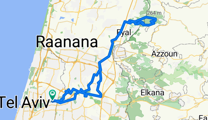
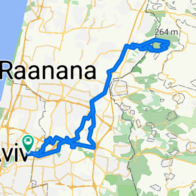
021020
A cycling route starting in Bnei Brak, Tel Aviv, Israel.
Overview
About this route
- -:--
- Duration
- 78.4 km
- Distance
- 286 m
- Ascent
- 285 m
- Descent
- ---
- Avg. speed
- ---
- Max. altitude

Continue with Bikemap
Use, edit, or download this cycling route
You would like to ride 021020 or customize it for your own trip? Here is what you can do with this Bikemap route:
Free features
- Save this route as favorite or in collections
- Copy & plan your own version of this route
- Sync your route with Garmin or Wahoo
Premium features
Free trial for 3 days, or one-time payment. More about Bikemap Premium.
- Navigate this route on iOS & Android
- Export a GPX / KML file of this route
- Create your custom printout (try it for free)
- Download this route for offline navigation
Discover more Premium features.
Get Bikemap PremiumFrom our community
Other popular routes starting in Bnei Brak
 test2
test2- Distance
- 32.5 km
- Ascent
- 171 m
- Descent
- 172 m
- Location
- Bnei Brak, Tel Aviv, Israel
 Herzlia high
- Distance
- 40.4 km
- Ascent
- 284 m
- Descent
- 287 m
- Location
- Bnei Brak, Tel Aviv, Israel
 test3
test3- Distance
- 16.8 km
- Ascent
- 173 m
- Descent
- 173 m
- Location
- Bnei Brak, Tel Aviv, Israel
 Restful route
- Distance
- 28.4 km
- Ascent
- 325 m
- Descent
- 355 m
- Location
- Bnei Brak, Tel Aviv, Israel
 לרכבת...
- Distance
- 4.5 km
- Ascent
- 25 m
- Descent
- 68 m
- Location
- Bnei Brak, Tel Aviv, Israel
 אופנידן – שביל הירקון: בני ברק → ראש העין (בהקמה)
- Distance
- 28.8 km
- Ascent
- 125 m
- Descent
- 106 m
- Location
- Bnei Brak, Tel Aviv, Israel
 Habarzel Street 18, Tel Aviv-Yafo to Hadera Street 13, Tel Aviv-Yafo
- Distance
- 8.3 km
- Ascent
- 37 m
- Descent
- 27 m
- Location
- Bnei Brak, Tel Aviv, Israel
 021020
- Distance
- 78.4 km
- Ascent
- 286 m
- Descent
- 285 m
- Location
- Bnei Brak, Tel Aviv, Israel
Open it in the app