

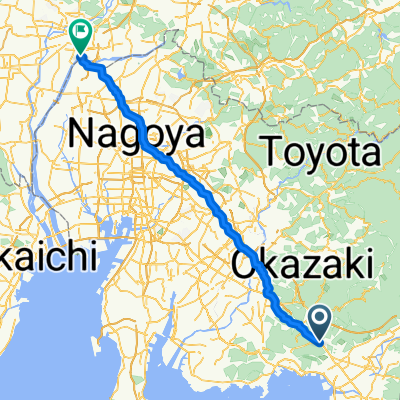
5-1, Ashinoya Mochida, Kota-Cho, Nukata-Gun to 20-22, Asukecho Naruse, Toyota-Shi
A cycling route starting in Gamagōri, Aichi, Japan.
Overview
About this route
- 4 h 10 min
- Duration
- 48 km
- Distance
- 831 m
- Ascent
- 738 m
- Descent
- 11.5 km/h
- Avg. speed
- ---
- Max. altitude
Route quality
Waytypes & surfaces along the route
Waytypes
Quiet road
24 km
(50 %)
Road
12.5 km
(26 %)
Surfaces
Paved
5.3 km
(11 %)
Paved (undefined)
4.3 km
(9 %)
Asphalt
1 km
(2 %)
Undefined
42.8 km
(89 %)
Continue with Bikemap
Use, edit, or download this cycling route
You would like to ride 5-1, Ashinoya Mochida, Kota-Cho, Nukata-Gun to 20-22, Asukecho Naruse, Toyota-Shi or customize it for your own trip? Here is what you can do with this Bikemap route:
Free features
- Save this route as favorite or in collections
- Copy & plan your own version of this route
- Sync your route with Garmin or Wahoo
Premium features
Free trial for 3 days, or one-time payment. More about Bikemap Premium.
- Navigate this route on iOS & Android
- Export a GPX / KML file of this route
- Create your custom printout (try it for free)
- Download this route for offline navigation
Discover more Premium features.
Get Bikemap PremiumFrom our community
Other popular routes starting in Gamagōri
 Gamagōri - Kasamatsuchō
- Distance
- 92.4 km
- Ascent
- 606 m
- Descent
- 649 m
- Location
- Gamagōri, Aichi, Japan
 Ogurimi, Gamagori to 1, Gamagori
- Distance
- 5.6 km
- Ascent
- 6 m
- Descent
- 89 m
- Location
- Gamagōri, Aichi, Japan
 Ushiro, Kota to 1-chōme 2, Okazaki
- Distance
- 12.3 km
- Ascent
- 73 m
- Descent
- 69 m
- Location
- Gamagōri, Aichi, Japan
 1_4_GAMAGIRI_HAMAMATSU_56km_150m
- Distance
- 55.8 km
- Ascent
- 164 m
- Descent
- 153 m
- Location
- Gamagōri, Aichi, Japan
 56, Miyakitadori 1-Chōme, Gamagori to 4-2, Taharacho Kamihachiken-ya, Tahara
- Distance
- 53.6 km
- Ascent
- 709 m
- Descent
- 699 m
- Location
- Gamagōri, Aichi, Japan
 Day 39: Hamamatsu
- Distance
- 181.1 km
- Ascent
- 1,154 m
- Descent
- 825 m
- Location
- Gamagōri, Aichi, Japan
 三河湾スカイライン
- Distance
- 16.8 km
- Ascent
- 600 m
- Descent
- 451 m
- Location
- Gamagōri, Aichi, Japan
 Gamagori_Hamatsu
- Distance
- 53.3 km
- Ascent
- 140 m
- Descent
- 119 m
- Location
- Gamagōri, Aichi, Japan
Open it in the app