

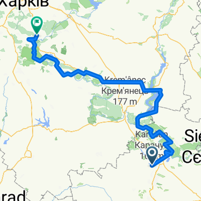
Славянськ Святогорск
A cycling route starting in Sloviansk, Donetsk Oblast, Ukraine.
Overview
About this route
- 4 h 16 min
- Duration
- 61.7 km
- Distance
- 949 m
- Ascent
- 957 m
- Descent
- 14.5 km/h
- Avg. speed
- ---
- Max. altitude

Continue with Bikemap
Use, edit, or download this cycling route
You would like to ride Славянськ Святогорск or customize it for your own trip? Here is what you can do with this Bikemap route:
Free features
- Save this route as favorite or in collections
- Copy & plan your own version of this route
- Sync your route with Garmin or Wahoo
Premium features
Free trial for 3 days, or one-time payment. More about Bikemap Premium.
- Navigate this route on iOS & Android
- Export a GPX / KML file of this route
- Create your custom printout (try it for free)
- Download this route for offline navigation
Discover more Premium features.
Get Bikemap PremiumFrom our community
Other popular routes starting in Sloviansk
 Славянськ Святогорск
- Distance
- 61.7 km
- Ascent
- 949 m
- Descent
- 957 m
- Location
- Sloviansk, Donetsk Oblast, Ukraine
 Славянск на пасху 2
- Distance
- 87.5 km
- Ascent
- 567 m
- Descent
- 566 m
- Location
- Sloviansk, Donetsk Oblast, Ukraine
 Славянск-Изюм
- Distance
- 83.2 km
- Ascent
- 349 m
- Descent
- 353 m
- Location
- Sloviansk, Donetsk Oblast, Ukraine
 Собирая апхилы...
- Distance
- 100.6 km
- Ascent
- 657 m
- Descent
- 669 m
- Location
- Sloviansk, Donetsk Oblast, Ukraine
 Slovyansk-Mayaki-Raygorodok-Slovyansk
- Distance
- 43.8 km
- Ascent
- 262 m
- Descent
- 263 m
- Location
- Sloviansk, Donetsk Oblast, Ukraine
 От ул. Аэродромная, Слов'янськ до ул. Аэродромная, Слов'янськ
- Distance
- 5.9 km
- Ascent
- 52 m
- Descent
- 51 m
- Location
- Sloviansk, Donetsk Oblast, Ukraine
 достопримечательности донецкой области
- Distance
- 84.7 km
- Ascent
- 295 m
- Descent
- 302 m
- Location
- Sloviansk, Donetsk Oblast, Ukraine
 Славянск-Харьков
- Distance
- 274.6 km
- Ascent
- 536 m
- Descent
- 505 m
- Location
- Sloviansk, Donetsk Oblast, Ukraine
Open it in the app