

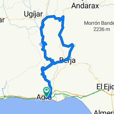
ADRA - TURÓN - BENÍNAR
A cycling route starting in Adra, Andalusia, Spain.
Overview
About this route
ADRA LA PARRA TURÓN BENÍNAR Ride through RÍO CHICO
- -:--
- Duration
- 60.2 km
- Distance
- 1,216 m
- Ascent
- 1,213 m
- Descent
- ---
- Avg. speed
- ---
- Max. altitude

Continue with Bikemap
Use, edit, or download this cycling route
You would like to ride ADRA - TURÓN - BENÍNAR or customize it for your own trip? Here is what you can do with this Bikemap route:
Free features
- Save this route as favorite or in collections
- Copy & plan your own version of this route
- Sync your route with Garmin or Wahoo
Premium features
Free trial for 3 days, or one-time payment. More about Bikemap Premium.
- Navigate this route on iOS & Android
- Export a GPX / KML file of this route
- Create your custom printout (try it for free)
- Download this route for offline navigation
Discover more Premium features.
Get Bikemap PremiumFrom our community
Other popular routes starting in Adra
 ADRA-BENÍNAR-LA PARRA
- Distance
- 60 km
- Ascent
- 1,252 m
- Descent
- 1,250 m
- Location
- Adra, Andalusia, Spain
 ADRA-TURÓN-BENÍNAR
- Distance
- 66 km
- Ascent
- 1,342 m
- Descent
- 1,342 m
- Location
- Adra, Andalusia, Spain
 Adra almeria
- Distance
- 87.3 km
- Ascent
- 2,912 m
- Descent
- 2,910 m
- Location
- Adra, Andalusia, Spain
 Adra - Guainos - La Parra
- Distance
- 23.7 km
- Ascent
- 798 m
- Descent
- 798 m
- Location
- Adra, Andalusia, Spain
 Adra - Guainos y cuestas
- Distance
- 43.6 km
- Ascent
- 1,158 m
- Descent
- 1,159 m
- Location
- Adra, Andalusia, Spain
 Adra to Almeria
- Distance
- 51.5 km
- Ascent
- 372 m
- Descent
- 357 m
- Location
- Adra, Andalusia, Spain
 ADRA - TURÓN - BENÍNAR
- Distance
- 60.2 km
- Ascent
- 1,216 m
- Descent
- 1,213 m
- Location
- Adra, Andalusia, Spain
 Subida a la Parra
- Distance
- 8.6 km
- Ascent
- 646 m
- Descent
- 66 m
- Location
- Adra, Andalusia, Spain
Open it in the app