

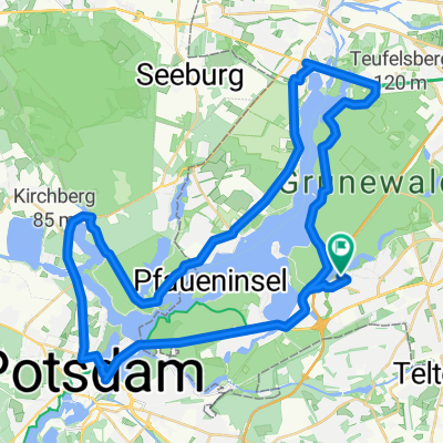
Wanderung auf dem "Havelhöhenweg"
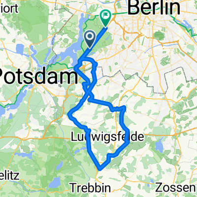
A cycling route starting in Nikolassee, Land Berlin, Germany.
Overview
About this route
Schöne Wanderung entlang der Havel, immer an der Abruchkante. Der Weg ist ein ewiges auf und ab über Treppen und Wurzeln. Vom Wanderweg gibt es immer wieder Ausblicke auf Havel, Kladow, Gatow und Spandau. Einkermöglichkeiten bestehen am Grunewaldturm und am Schildhorn. / Hinweis wir haben mit unseren Kindern (4 und 6 Jahre ) 3,5 Std. für die Wanderung gebraucht. / Die Einstufung als leichte Wanderung basiert auf einer Relation, die auch auf Alpentouren anwendbar ist. Für Flachwanderer aus meiner Heimat Berlin/Brandenburg mögen manche Steigungen schon eine Herausforderung bedeuten
- -:--
- Duration
- 11.4 km
- Distance
- 218 m
- Ascent
- 214 m
- Descent
- ---
- Avg. speed
- ---
- Max. altitude
Continue with Bikemap
Use, edit, or download this cycling route
You would like to ride Wanderung auf dem "Havelhöhenweg" or customize it for your own trip? Here is what you can do with this Bikemap route:
Free features
- Save this route as favorite or in collections
- Copy & plan your own version of this route
- Sync your route with Garmin or Wahoo
Premium features
Free trial for 3 days, or one-time payment. More about Bikemap Premium.
- Navigate this route on iOS & Android
- Export a GPX / KML file of this route
- Create your custom printout (try it for free)
- Download this route for offline navigation
Discover more Premium features.
Get Bikemap PremiumFrom our community
Other popular routes starting in Nikolassee
 Kleine Runde nach Thyrow
- Distance
- 72.4 km
- Ascent
- 118 m
- Descent
- 127 m
- Location
- Nikolassee, Land Berlin, Germany
 Rund um die Havel
- Distance
- 54 km
- Ascent
- 261 m
- Descent
- 261 m
- Location
- Nikolassee, Land Berlin, Germany
 Sacrowrunde Cross
- Distance
- 68.3 km
- Ascent
- 350 m
- Descent
- 357 m
- Location
- Nikolassee, Land Berlin, Germany
 Rund um´s Kloster
- Distance
- 122.4 km
- Ascent
- 298 m
- Descent
- 311 m
- Location
- Nikolassee, Land Berlin, Germany
 BERLIN 2018
- Distance
- 777.6 km
- Ascent
- 339 m
- Descent
- 334 m
- Location
- Nikolassee, Land Berlin, Germany
 Rund um den Wannsee 2
- Distance
- 43.8 km
- Ascent
- 180 m
- Descent
- 184 m
- Location
- Nikolassee, Land Berlin, Germany
 Rund um die Havel
- Distance
- 54 km
- Ascent
- 261 m
- Descent
- 261 m
- Location
- Nikolassee, Land Berlin, Germany
 Spinnertour
- Distance
- 26.8 km
- Ascent
- 270 m
- Descent
- 255 m
- Location
- Nikolassee, Land Berlin, Germany
Open it in the app