Μ-Σ-Μ
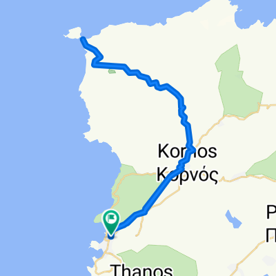
A cycling route starting in Myrina, North Aegean, Greece.
Overview
About this route
ΜΥΡΙΝΑ - ΣΑΡΔΕΣ - ΜΥΡΙΝΑ
- -:--
- Duration
- 20.6 km
- Distance
- 280 m
- Ascent
- 281 m
- Descent
- ---
- Avg. speed
- ---
- Avg. speed
Route quality
Waytypes & surfaces along the route
Waytypes
Busy road
15.5 km
(75 %)
Road
5 km
(24 %)
Surfaces
Paved
16.5 km
(80 %)
Asphalt
16.4 km
(80 %)
Paving stones
0.1 km
(<1 %)
Undefined
4.1 km
(20 %)
Continue with Bikemap
Use, edit, or download this cycling route
You would like to ride Μ-Σ-Μ or customize it for your own trip? Here is what you can do with this Bikemap route:
Free features
- Save this route as favorite or in collections
- Copy & plan your own version of this route
- Sync your route with Garmin or Wahoo
Premium features
Free trial for 3 days, or one-time payment. More about Bikemap Premium.
- Navigate this route on iOS & Android
- Export a GPX / KML file of this route
- Create your custom printout (try it for free)
- Download this route for offline navigation
Discover more Premium features.
Get Bikemap PremiumFrom our community
Other popular routes starting in Myrina
- Μ-Α-Μ
- Distance
- 41.3 km
- Ascent
- 366 m
- Descent
- 367 m
- Location
- Myrina, North Aegean, Greece
- Μ-Κ-Φ-Κ-Ε-Θ-Π-Μ
- Distance
- 30.7 km
- Ascent
- 325 m
- Descent
- 323 m
- Location
- Myrina, North Aegean, Greece
- Μ-ΑΔ-Μ
- Distance
- 23.7 km
- Ascent
- 254 m
- Descent
- 254 m
- Location
- Myrina, North Aegean, Greece
- Lemnos Cycling 2013
- Distance
- 214 km
- Ascent
- 843 m
- Descent
- 842 m
- Location
- Myrina, North Aegean, Greece
- Lemnos Cycling 2013
- Distance
- 105.1 km
- Ascent
- 613 m
- Descent
- 617 m
- Location
- Myrina, North Aegean, Greece
- Μ-Ε-Κ-Ε-Μ
- Distance
- 23.9 km
- Ascent
- 343 m
- Descent
- 345 m
- Location
- Myrina, North Aegean, Greece
- Μ-Σ-Μ
- Distance
- 20.6 km
- Ascent
- 280 m
- Descent
- 281 m
- Location
- Myrina, North Aegean, Greece
- Μ-Π-ΑΠ-Π-Μ
- Distance
- 16.3 km
- Ascent
- 168 m
- Descent
- 170 m
- Location
- Myrina, North Aegean, Greece