
Eder-Bike-Tour 2008
A cycling route starting in Erndtebrück, North Rhine-Westphalia, Germany.
Overview
About this route
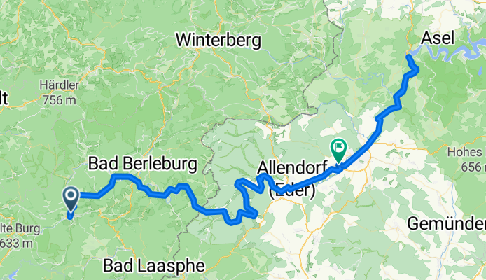
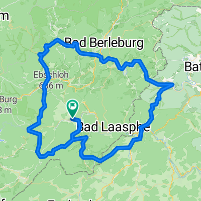
Eder-Bike-Tour 2008
Erndtebrück-Bad Berleburg-Hatzfeld-Dodenau-Battenfeld-Frankenberg-Herzahausen-Frankenberg
- -:--
- Duration
- 107.4 km
- Distance
- 625 m
- Ascent
- 831 m
- Descent
- ---
- Avg. speed
- 546 m
- Max. altitude
Route quality
Waytypes & surfaces along the route
Waytypes
Track
29 km
(27 %)
Quiet road
16.1 km
(15 %)
Surfaces
Paved
65.5 km
(61 %)
Unpaved
18.3 km
(17 %)
Asphalt
64.5 km
(60 %)
Gravel
16.1 km
(15 %)
Continue with Bikemap
Use, edit, or download this cycling route
You would like to ride Eder-Bike-Tour 2008 or customize it for your own trip? Here is what you can do with this Bikemap route:
Free features
- Save this route as favorite or in collections
- Copy & plan your own version of this route
- Split it into stages to create a multi-day tour
- Sync your route with Garmin or Wahoo
Premium features
Free trial for 3 days, or one-time payment. More about Bikemap Premium.
- Navigate this route on iOS & Android
- Export a GPX / KML file of this route
- Create your custom printout (try it for free)
- Download this route for offline navigation
Discover more Premium features.
Get Bikemap PremiumFrom our community
Other popular routes starting in Erndtebrück
 Rund um den Dreiherrenstein
- Distance
- 62.2 km
- Ascent
- 785 m
- Descent
- 788 m
- Location
- Erndtebrück, North Rhine-Westphalia, Germany
 erndtebrück zinse röspe erndtebrück
- Distance
- 11.3 km
- Ascent
- 135 m
- Descent
- 194 m
- Location
- Erndtebrück, North Rhine-Westphalia, Germany
 2. Lahnquelle - Marburg
- Distance
- 67.3 km
- Ascent
- 539 m
- Descent
- 945 m
- Location
- Erndtebrück, North Rhine-Westphalia, Germany
 Ilsetal-Edertal-R8-Perftalsee-Banfetal
- Distance
- 100.9 km
- Ascent
- 751 m
- Descent
- 750 m
- Location
- Erndtebrück, North Rhine-Westphalia, Germany
 Ferndorfquelle
- Distance
- 15.7 km
- Ascent
- 270 m
- Descent
- 258 m
- Location
- Erndtebrück, North Rhine-Westphalia, Germany
 Ilsetal-Fischelbach-Dietzhölztal-Hainchen-Deutz-Siegquelle-Benfe-Leimstruth
- Distance
- 76.7 km
- Ascent
- 851 m
- Descent
- 855 m
- Location
- Erndtebrück, North Rhine-Westphalia, Germany
 lahntal feudingen-koblenz
- Distance
- 250.8 km
- Ascent
- 2,199 m
- Descent
- 2,514 m
- Location
- Erndtebrück, North Rhine-Westphalia, Germany
 5 Bäche-Tour: Eder, Lahn, Perf, Banfe + Ilse
- Distance
- 104.4 km
- Ascent
- 909 m
- Descent
- 912 m
- Location
- Erndtebrück, North Rhine-Westphalia, Germany
Open it in the app