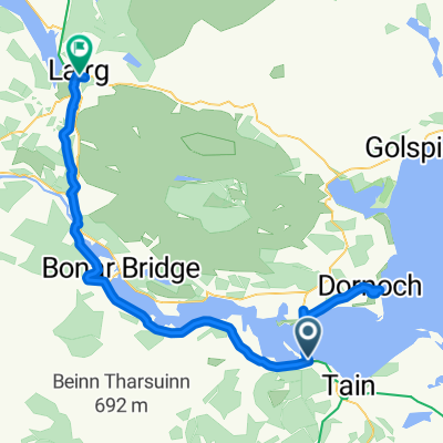
Jog2LE Day Two
A cycling route starting in Tain, Scotland, United Kingdom.
Overview
About this route
<h6 class="uiStreamMessage"></h6>
- -:--
- Duration
- 140.2 km
- Distance
- 669 m
- Ascent
- 633 m
- Descent
- ---
- Avg. speed
- ---
- Avg. speed
Route highlights
Points of interest along the route
Point of interest after 33 km
First stop for morning tea at Ardullie
Point of interest after 64.8 km
Second stop for lunch just passed Ardendrain
Point of interest after 97.6 km
Third stop for afternoon tea
Continue with Bikemap
Use, edit, or download this cycling route
You would like to ride Jog2LE Day Two or customize it for your own trip? Here is what you can do with this Bikemap route:
Free features
- Save this route as favorite or in collections
- Copy & plan your own version of this route
- Sync your route with Garmin or Wahoo
Premium features
Free trial for 3 days, or one-time payment. More about Bikemap Premium.
- Navigate this route on iOS & Android
- Export a GPX / KML file of this route
- Create your custom printout (try it for free)
- Download this route for offline navigation
Discover more Premium features.
Get Bikemap PremiumFrom our community
Other popular routes starting in Tain
- Scotland Day 3
- Distance
- 162.7 km
- Ascent
- 932 m
- Descent
- 756 m
- Location
- Tain, Scotland, United Kingdom
- Alness to Tain pilgrim route
- Distance
- 9.4 km
- Ascent
- 55 m
- Descent
- 126 m
- Location
- Tain, Scotland, United Kingdom
- Route 1 Altnaharra
- Distance
- 69.5 km
- Ascent
- 39 m
- Descent
- 61 m
- Location
- Tain, Scotland, United Kingdom
- D3New
- Distance
- 148.5 km
- Ascent
- 945 m
- Descent
- 762 m
- Location
- Tain, Scotland, United Kingdom
- Jog2LE Day Two
- Distance
- 140.2 km
- Ascent
- 669 m
- Descent
- 633 m
- Location
- Tain, Scotland, United Kingdom
- 08_Tain-Lairg_2016-06-26
- Distance
- 63.6 km
- Ascent
- 255 m
- Descent
- 168 m
- Location
- Tain, Scotland, United Kingdom
- Tain Cycling
- Distance
- 59.7 km
- Ascent
- 452 m
- Descent
- 501 m
- Location
- Tain, Scotland, United Kingdom
- periple 11 / 24
- Distance
- 125.7 km
- Ascent
- 754 m
- Descent
- 683 m
- Location
- Tain, Scotland, United Kingdom
Open it in the app