
Krovenzjochrunde
A cycling route starting in Kolsassberg, Tyrol, Austria.
Overview
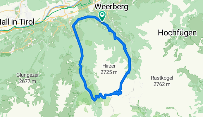
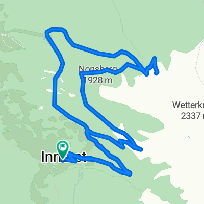
About this route
From the Jägerhof Hotel to Weertal. There, turn towards Krovenzjoch. You can ride your bike up to about 2250m, it’s a bit steep, but you can pedal. The last 200m of elevation to the Joch must be pushed. Experienced riders can also descend completely from the Joch. From about 2200m, there is a well-drivable path.
At the valley floor, you reach the military exclusion zone of Wattener Lizum. This is usually problem-free, except during shooting exercises.
Descent on a narrow but paved road towards Birchach and from there to a farm. Here, a nearly impassable trail begins, but you lose hardly any elevation.
The Joch is very suitable as a starting point for Bike & Hike tours, e.g., to Krovenzspitze (~30min), Hirzer (~2h), or Hippoltspitze (~30min).
The preferred direction for this tour is clockwise: less traffic on the ascent and gentler inclines.
- -:--
- Duration
- 36.2 km
- Distance
- 1,606 m
- Ascent
- 1,611 m
- Descent
- ---
- Avg. speed
- ---
- Max. altitude

Continue with Bikemap
Use, edit, or download this cycling route
You would like to ride Krovenzjochrunde or customize it for your own trip? Here is what you can do with this Bikemap route:
Free features
- Save this route as favorite or in collections
- Copy & plan your own version of this route
- Sync your route with Garmin or Wahoo
Premium features
Free trial for 3 days, or one-time payment. More about Bikemap Premium.
- Navigate this route on iOS & Android
- Export a GPX / KML file of this route
- Create your custom printout (try it for free)
- Download this route for offline navigation
Discover more Premium features.
Get Bikemap PremiumFrom our community
Other popular routes starting in Kolsassberg
 Hintertux
- Distance
- 50.5 km
- Ascent
- 1,813 m
- Descent
- 2,219 m
- Location
- Kolsassberg, Tyrol, Austria
 Povers
- Distance
- 5.4 km
- Ascent
- 42 m
- Descent
- 526 m
- Location
- Kolsassberg, Tyrol, Austria
 Transalp 2017 #3
- Distance
- 51.8 km
- Ascent
- 1,786 m
- Descent
- 2,192 m
- Location
- Kolsassberg, Tyrol, Austria
 Tag 2. Weidener Hütte - Tuxer Joch Haus
- Distance
- 29.6 km
- Ascent
- 1,556 m
- Descent
- 1,041 m
- Location
- Kolsassberg, Tyrol, Austria
 Rundtour um die Lafasteralm
- Distance
- 20.7 km
- Ascent
- 811 m
- Descent
- 811 m
- Location
- Kolsassberg, Tyrol, Austria
 Krovenzjochrunde
- Distance
- 36.2 km
- Ascent
- 1,606 m
- Descent
- 1,611 m
- Location
- Kolsassberg, Tyrol, Austria
 3_Weidener Huette
- Distance
- 50.4 km
- Ascent
- 1,821 m
- Descent
- 2,230 m
- Location
- Kolsassberg, Tyrol, Austria
 dante tura
- Distance
- 51.7 km
- Ascent
- 1,050 m
- Descent
- 24 m
- Location
- Kolsassberg, Tyrol, Austria
Open it in the app