
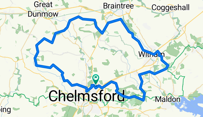
Springfield- North- 50miles loop
A cycling route starting in Chelmsford, England, United Kingdom.
Overview
About this route
Springfield- Good Easter- Felsted-Black Notley - White Notley - Witham - Woodham Walter- Little Baddow - Boreham - loop
- 3 h 25 min
- Duration
- 82.4 km
- Distance
- 343 m
- Ascent
- 343 m
- Descent
- 24.1 km/h
- Avg. speed
- ---
- Max. altitude

Route quality
Waytypes & surfaces along the route
Waytypes
Road
56.9 km
(69 %)
Quiet road
14.8 km
(18 %)
Surfaces
Paved
35.4 km
(43 %)
Asphalt
34.6 km
(42 %)
Paved (undefined)
0.8 km
(1 %)
Undefined
47 km
(57 %)
Continue with Bikemap
Use, edit, or download this cycling route
You would like to ride Springfield- North- 50miles loop or customize it for your own trip? Here is what you can do with this Bikemap route:
Free features
- Save this route as favorite or in collections
- Copy & plan your own version of this route
- Split it into stages to create a multi-day tour
- Sync your route with Garmin or Wahoo
Premium features
Free trial for 3 days, or one-time payment. More about Bikemap Premium.
- Navigate this route on iOS & Android
- Export a GPX / KML file of this route
- Create your custom printout (try it for free)
- Download this route for offline navigation
Discover more Premium features.
Get Bikemap PremiumFrom our community
Other popular routes starting in Chelmsford
 Pre-Work No1
- Distance
- 38 km
- Ascent
- 177 m
- Descent
- 177 m
- Location
- Chelmsford, England, United Kingdom
 My Biggest Ride yet, outter Chelmsford excursion
- Distance
- 50.9 km
- Ascent
- 214 m
- Descent
- 214 m
- Location
- Chelmsford, England, United Kingdom
 20k Moulsham Broomfield Springfield loop
- Distance
- 19.7 km
- Ascent
- 77 m
- Descent
- 81 m
- Location
- Chelmsford, England, United Kingdom
 1st decent ride of the summer 34+
- Distance
- 55.6 km
- Ascent
- 235 m
- Descent
- 235 m
- Location
- Chelmsford, England, United Kingdom
 Springfield - Stock - Inga - Writtle
- Distance
- 38.5 km
- Ascent
- 230 m
- Descent
- 231 m
- Location
- Chelmsford, England, United Kingdom
 Snail-like route in Chelmsford
- Distance
- 16.5 km
- Ascent
- 0 m
- Descent
- 0 m
- Location
- Chelmsford, England, United Kingdom
 Moderate route in Chelmsford
- Distance
- 14.8 km
- Ascent
- 52 m
- Descent
- 52 m
- Location
- Chelmsford, England, United Kingdom
 Baddow, Galleywood, Margreting, to Writtle, Through Chelmsford, to Sanford Mill, Danbury and back to Baddow
- Distance
- 37.5 km
- Ascent
- 222 m
- Descent
- 222 m
- Location
- Chelmsford, England, United Kingdom
Open it in the app