

Grangeway 19 to Connah's Quay Road 59, Northop
A cycling route starting in Runcorn, England, United Kingdom.
Overview
About this route
- 2 h 26 min
- Duration
- 41.5 km
- Distance
- 337 m
- Ascent
- 287 m
- Descent
- 17 km/h
- Avg. speed
- ---
- Max. altitude

Route quality
Waytypes & surfaces along the route
Waytypes
Cycleway
17.4 km
(42 %)
Quiet road
9.1 km
(22 %)
Surfaces
Paved
24 km
(58 %)
Unpaved
4.1 km
(10 %)
Asphalt
19.9 km
(48 %)
Paved (undefined)
4.1 km
(10 %)
Continue with Bikemap
Use, edit, or download this cycling route
You would like to ride Grangeway 19 to Connah's Quay Road 59, Northop or customize it for your own trip? Here is what you can do with this Bikemap route:
Free features
- Save this route as favorite or in collections
- Copy & plan your own version of this route
- Sync your route with Garmin or Wahoo
Premium features
Free trial for 3 days, or one-time payment. More about Bikemap Premium.
- Navigate this route on iOS & Android
- Export a GPX / KML file of this route
- Create your custom printout (try it for free)
- Download this route for offline navigation
Discover more Premium features.
Get Bikemap PremiumFrom our community
Other popular routes starting in Runcorn
 Steady ride in Runcorn
- Distance
- 70.7 km
- Ascent
- 45 m
- Descent
- 72 m
- Location
- Runcorn, England, United Kingdom
 50 Moughland Lane, Runcorn to 50 Moughland Lane, Runcorn
- Distance
- 15.8 km
- Ascent
- 103 m
- Descent
- 95 m
- Location
- Runcorn, England, United Kingdom
 runcorn
- Distance
- 14.3 km
- Ascent
- 66 m
- Descent
- 65 m
- Location
- Runcorn, England, United Kingdom
 Chaucer Street do Ashton New Road
- Distance
- 54.4 km
- Ascent
- 204 m
- Descent
- 229 m
- Location
- Runcorn, England, United Kingdom
 13 Runcorn to Blackburn 28th May
- Distance
- 66.6 km
- Ascent
- 453 m
- Descent
- 354 m
- Location
- Runcorn, England, United Kingdom
 Grangeway 17 to Myrtle Avenue 7
- Distance
- 85.7 km
- Ascent
- 730 m
- Descent
- 764 m
- Location
- Runcorn, England, United Kingdom
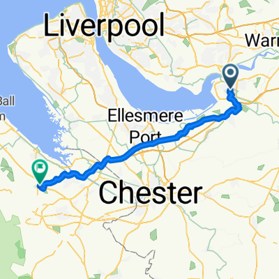 Grangeway 19 to Connah's Quay Road 59, Northop
- Distance
- 41.5 km
- Ascent
- 337 m
- Descent
- 287 m
- Location
- Runcorn, England, United Kingdom
 Grangeway 15 to London Street 16
- Distance
- 52.5 km
- Ascent
- 268 m
- Descent
- 307 m
- Location
- Runcorn, England, United Kingdom
Open it in the app