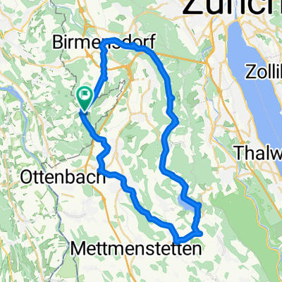
Argovia: Höhen und Flüsse
A cycling route starting in Oberlunkhofen, Canton of Aargau, Switzerland.
Overview
About this route
- -:--
- Duration
- 132.1 km
- Distance
- 1,140 m
- Ascent
- 1,140 m
- Descent
- ---
- Avg. speed
- ---
- Avg. speed
Route quality
Waytypes & surfaces along the route
Waytypes
Road
46.4 km
(35 %)
Busy road
28.5 km
(22 %)
Surfaces
Paved
109.8 km
(83 %)
Unpaved
0.5 km
(<1 %)
Asphalt
96.3 km
(73 %)
Paved (undefined)
13.1 km
(10 %)
Route highlights
Points of interest along the route
Drinking water after 60.9 km
Continue with Bikemap
Use, edit, or download this cycling route
You would like to ride Argovia: Höhen und Flüsse or customize it for your own trip? Here is what you can do with this Bikemap route:
Free features
- Save this route as favorite or in collections
- Copy & plan your own version of this route
- Sync your route with Garmin or Wahoo
Premium features
Free trial for 3 days, or one-time payment. More about Bikemap Premium.
- Navigate this route on iOS & Android
- Export a GPX / KML file of this route
- Create your custom printout (try it for free)
- Download this route for offline navigation
Discover more Premium features.
Get Bikemap PremiumFrom our community
Other popular routes starting in Oberlunkhofen
- Sins-Muri
- Distance
- 41.2 km
- Ascent
- 296 m
- Descent
- 297 m
- Location
- Oberlunkhofen, Canton of Aargau, Switzerland
- Argovia: Höhen und Flüsse
- Distance
- 132.1 km
- Ascent
- 1,140 m
- Descent
- 1,140 m
- Location
- Oberlunkhofen, Canton of Aargau, Switzerland
- OL-Meisterschwanden-Sins
- Distance
- 85.6 km
- Ascent
- 812 m
- Descent
- 811 m
- Location
- Oberlunkhofen, Canton of Aargau, Switzerland
- Beromünster Sendeturm (Tour A)
- Distance
- 111.4 km
- Ascent
- 1,457 m
- Descent
- 1,457 m
- Location
- Oberlunkhofen, Canton of Aargau, Switzerland
- Albis 10 Pässefahrt
- Distance
- 62.1 km
- Ascent
- 1,465 m
- Descent
- 1,465 m
- Location
- Oberlunkhofen, Canton of Aargau, Switzerland
- Türlersee
- Distance
- 37.2 km
- Ascent
- 454 m
- Descent
- 439 m
- Location
- Oberlunkhofen, Canton of Aargau, Switzerland
- Reppistal
- Distance
- 25 km
- Ascent
- 362 m
- Descent
- 358 m
- Location
- Oberlunkhofen, Canton of Aargau, Switzerland
- Arni Sins Rundfahrt
- Distance
- 54.4 km
- Ascent
- 429 m
- Descent
- 429 m
- Location
- Oberlunkhofen, Canton of Aargau, Switzerland
Open it in the app