
Ötscherland-Radroute
A cycling route starting in Pöchlarn, Lower Austria, Austria.
Overview
About this route
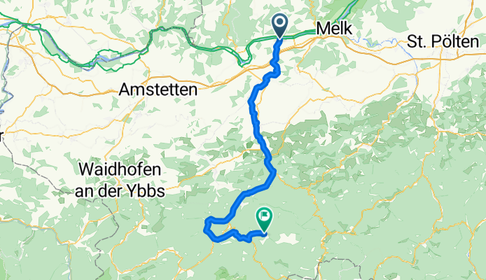
Der Ötscher ist der weithin bekannte und sichtbare Hausberg der Mostviertler. Diese Radtour lädt zur horizontalen Annäherung an den imposanten Berg Tritt für Tritt an. Die Ötscherland-Radtour beginnt an der Donau bei Pöchlarn (Alternative ab Ybbs), sie endet für Familien-Radler in Gaming, für sportlich Ambitionierte in Lackenhof. In Lunz am See knüpft er an den Ybbstalradweg an. Dazwischen laden Naturidyllen an der Erlauf zum erquickenden Zwischenstopp, Markt- und Stadtkerne zu kurzen Entdeckungstouren ein. Dass die Zielrichtung nicht aus dem Auge verloren wird, dafür sorgt nicht nur das Flussbett der Erlauf, sondern auch das vielerorts auf der Route gegenwärtige Anlitz des Ötschers.
- -:--
- Duration
- 68.9 km
- Distance
- 1,140 m
- Ascent
- 543 m
- Descent
- ---
- Avg. speed
- ---
- Max. altitude
Route quality
Waytypes & surfaces along the route
Waytypes
Road
24.3 km
(35 %)
Quiet road
21.3 km
(31 %)
Surfaces
Paved
62 km
(90 %)
Unpaved
2.3 km
(3 %)
Asphalt
55.9 km
(81 %)
Paved (undefined)
6.2 km
(9 %)
Continue with Bikemap
Use, edit, or download this cycling route
You would like to ride Ötscherland-Radroute or customize it for your own trip? Here is what you can do with this Bikemap route:
Free features
- Save this route as favorite or in collections
- Copy & plan your own version of this route
- Sync your route with Garmin or Wahoo
Premium features
Free trial for 3 days, or one-time payment. More about Bikemap Premium.
- Navigate this route on iOS & Android
- Export a GPX / KML file of this route
- Create your custom printout (try it for free)
- Download this route for offline navigation
Discover more Premium features.
Get Bikemap PremiumFrom our community
Other popular routes starting in Pöchlarn
 Radrundfahrt Donauradweg Bezirk Melk
- Distance
- 63.2 km
- Ascent
- 99 m
- Descent
- 100 m
- Location
- Pöchlarn, Lower Austria, Austria
 200er
200er- Distance
- 203.4 km
- Ascent
- 1,257 m
- Descent
- 1,252 m
- Location
- Pöchlarn, Lower Austria, Austria
 Ötscherland-Radroute
- Distance
- 68.9 km
- Ascent
- 1,140 m
- Descent
- 543 m
- Location
- Pöchlarn, Lower Austria, Austria
 Kleine Rundfahrt - Donaulände Bezirk Melk
- Distance
- 31.8 km
- Ascent
- 112 m
- Descent
- 112 m
- Location
- Pöchlarn, Lower Austria, Austria
 Ötscher- Ybbstal Radweg
- Distance
- 156.9 km
- Ascent
- 590 m
- Descent
- 592 m
- Location
- Pöchlarn, Lower Austria, Austria
 Zelking-Wien
- Distance
- 130.6 km
- Ascent
- 610 m
- Descent
- 598 m
- Location
- Pöchlarn, Lower Austria, Austria
 Erlauftalradweg (ehem. Oetscherland-Radroute)
- Distance
- 62.6 km
- Ascent
- 958 m
- Descent
- 578 m
- Location
- Pöchlarn, Lower Austria, Austria
 Schiffhausweg 1, Am Rechen to Wiener Straße 3, Melk
- Distance
- 12.9 km
- Ascent
- 3 m
- Descent
- 6 m
- Location
- Pöchlarn, Lower Austria, Austria
Open it in the app