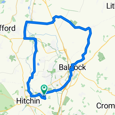
Herts Hoop
A cycling route starting in Hitchin, England, United Kingdom.
Overview
About this route
- 5 h 46 min
- Duration
- 18.9 km
- Distance
- 398 m
- Ascent
- 407 m
- Descent
- 3.3 km/h
- Avg. speed
- ---
- Max. altitude
Continue with Bikemap
Use, edit, or download this cycling route
You would like to ride Herts Hoop or customize it for your own trip? Here is what you can do with this Bikemap route:
Free features
- Save this route as favorite or in collections
- Copy & plan your own version of this route
- Sync your route with Garmin or Wahoo
Premium features
Free trial for 3 days, or one-time payment. More about Bikemap Premium.
- Navigate this route on iOS & Android
- Export a GPX / KML file of this route
- Create your custom printout (try it for free)
- Download this route for offline navigation
Discover more Premium features.
Get Bikemap PremiumFrom our community
Other popular routes starting in Hitchin
nice route- Distance
- 12.6 km
- Ascent
- 80 m
- Descent
- 82 m
- Location
- Hitchin, England, United Kingdom
Wilbury Way, Hitchin to Station Parade, Letchworth Garden City- Distance
- 4.8 km
- Ascent
- 42 m
- Descent
- 17 m
- Location
- Hitchin, England, United Kingdom
Preston Road, Hitchin to Preston Road, Hitchin- Distance
- 22.5 km
- Ascent
- 253 m
- Descent
- 254 m
- Location
- Hitchin, England, United Kingdom
Herts Hoop- Distance
- 18.9 km
- Ascent
- 398 m
- Descent
- 407 m
- Location
- Hitchin, England, United Kingdom
Saint John's Road to Langbridge Close- Distance
- 20.9 km
- Ascent
- 113 m
- Descent
- 168 m
- Location
- Hitchin, England, United Kingdom
67 Talbot St, Hitchin to 65 Talbot St, Hitchin- Distance
- 23.9 km
- Ascent
- 134 m
- Descent
- 137 m
- Location
- Hitchin, England, United Kingdom
Willian-Wymondley loop- Distance
- 13 km
- Ascent
- 91 m
- Descent
- 91 m
- Location
- Hitchin, England, United Kingdom
Langford Tower Via Baldock- Distance
- 40.6 km
- Ascent
- 283 m
- Descent
- 283 m
- Location
- Hitchin, England, United Kingdom
Open it in the app

