
2 Tal der Tränen und Korkenzieher
A cycling route starting in Playa del Ingles, Canary Islands, Spain.
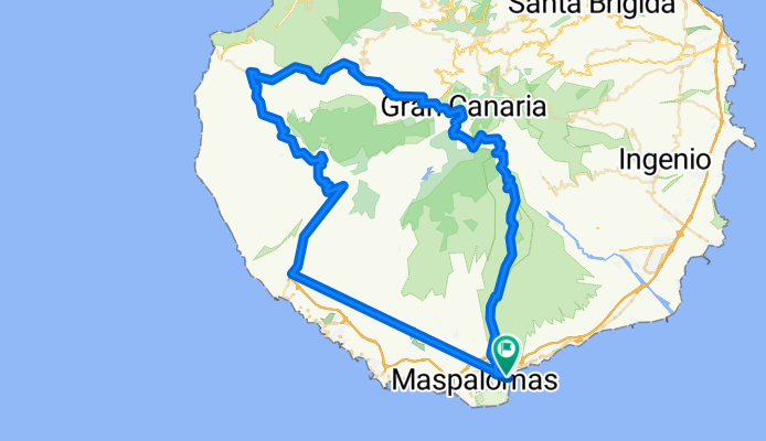
Overview
About this route
Zuerst mit dem Bike Shuttle von Plya del Ingles nach Mogan (die Straße zwischen Taurito und Playa de Mogan ist gesperrt).
Abzweigung beim Stausee, vor dem Tunnel rechts, hinauf zum Tal der Tränen durchgehend brutal steil – nur für Hardcore-Biker!
- -:--
- Duration
- 116 km
- Distance
- 5,144 m
- Ascent
- 5,144 m
- Descent
- ---
- Avg. speed
- 1,437 m
- Avg. speed

Route highlights
Points of interest along the route
Point of interest after 52.5 km
Spar zum Einkaufen - es gibt 30km (1.300HM) nichts mehr !
Point of interest after 80 km
Bar Casa Melo
Continue with Bikemap
Use, edit, or download this cycling route
You would like to ride 2 Tal der Tränen und Korkenzieher or customize it for your own trip? Here is what you can do with this Bikemap route:
Free features
- Save this route as favorite or in collections
- Copy & plan your own version of this route
- Split it into stages to create a multi-day tour
- Sync your route with Garmin or Wahoo
Premium features
Free trial for 3 days, or one-time payment. More about Bikemap Premium.
- Navigate this route on iOS & Android
- Export a GPX / KML file of this route
- Create your custom printout (try it for free)
- Download this route for offline navigation
Discover more Premium features.
Get Bikemap PremiumFrom our community
Other popular routes starting in Playa del Ingles
 Rundtour: Chira - San Bartolome - Santa Lucia
- Distance
- 90.2 km
- Ascent
- 1,477 m
- Descent
- 1,478 m
- Location
- Playa del Ingles, Canary Islands, Spain
 GC - Pico Gipfelsturm von Osten
- Distance
- 106.6 km
- Ascent
- 2,165 m
- Descent
- 2,165 m
- Location
- Playa del Ingles, Canary Islands, Spain
 Tour 1
- Distance
- 82.9 km
- Ascent
- 1,581 m
- Descent
- 1,584 m
- Location
- Playa del Ingles, Canary Islands, Spain
 Tal der Tränen
- Distance
- 121.9 km
- Ascent
- 2,300 m
- Descent
- 2,305 m
- Location
- Playa del Ingles, Canary Islands, Spain
 Agüimes Santa Lucia
- Distance
- 83.3 km
- Ascent
- 2,528 m
- Descent
- 2,249 m
- Location
- Playa del Ingles, Canary Islands, Spain
 gran canaria 2
- Distance
- 95.5 km
- Ascent
- 1,221 m
- Descent
- 1,196 m
- Location
- Playa del Ingles, Canary Islands, Spain
 Auf das Dach der Insel
- Distance
- 113 km
- Ascent
- 5,680 m
- Descent
- 5,564 m
- Location
- Playa del Ingles, Canary Islands, Spain
 San Bartolome Runde
- Distance
- 67.5 km
- Ascent
- 1,986 m
- Descent
- 1,985 m
- Location
- Playa del Ingles, Canary Islands, Spain
Open it in the app