

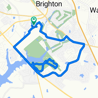
Margeau's Route
A cycling route starting in Lexington, Kentucky, United States of America.
Overview
About this route
- -:--
- Duration
- 15.4 km
- Distance
- 65 m
- Ascent
- 64 m
- Descent
- ---
- Avg. speed
- ---
- Max. altitude
Route quality
Waytypes & surfaces along the route
Waytypes
Quiet road
6.6 km
(43 %)
Busy road
3.6 km
(24 %)
Surfaces
Paved
8 km
(52 %)
Asphalt
8 km
(52 %)
Concrete
0 km
(<1 %)
Undefined
7.4 km
(48 %)
Route highlights
Points of interest along the route
Point of interest after 3.8 km
Margaeu's Apartment
Point of interest after 10.7 km
Athenian Grill
Continue with Bikemap
Use, edit, or download this cycling route
You would like to ride Margeau's Route or customize it for your own trip? Here is what you can do with this Bikemap route:
Free features
- Save this route as favorite or in collections
- Copy & plan your own version of this route
- Sync your route with Garmin or Wahoo
Premium features
Free trial for 3 days, or one-time payment. More about Bikemap Premium.
- Navigate this route on iOS & Android
- Export a GPX / KML file of this route
- Create your custom printout (try it for free)
- Download this route for offline navigation
Discover more Premium features.
Get Bikemap PremiumFrom our community
Other popular routes starting in Lexington
 Starters
- Distance
- 2.6 km
- Ascent
- 20 m
- Descent
- 22 m
- Location
- Lexington, Kentucky, United States of America
 To Sheila's House
- Distance
- 10.2 km
- Ascent
- 59 m
- Descent
- 58 m
- Location
- Lexington, Kentucky, United States of America
 Fairy route
- Distance
- 34.7 km
- Ascent
- 240 m
- Descent
- 379 m
- Location
- Lexington, Kentucky, United States of America
 Moderate route in Lexington
- Distance
- 7.8 km
- Ascent
- 48 m
- Descent
- 49 m
- Location
- Lexington, Kentucky, United States of America
 MA213 Recitation
- Distance
- 5.1 km
- Ascent
- 51 m
- Descent
- 57 m
- Location
- Lexington, Kentucky, United States of America
 Moderate route in Lexington
- Distance
- 15.2 km
- Ascent
- 117 m
- Descent
- 116 m
- Location
- Lexington, Kentucky, United States of America
 Hartland Park 31-mile Out-n-back to Ky River
- Distance
- 50.4 km
- Ascent
- 260 m
- Descent
- 260 m
- Location
- Lexington, Kentucky, United States of America
 East Lexington toBluegrass Christian Camp
- Distance
- 48 km
- Ascent
- 240 m
- Descent
- 246 m
- Location
- Lexington, Kentucky, United States of America
Open it in the app