Bellingham-Ferndale-RedRiver-MariettaLoop
A cycling route starting in Bellingham, Washington, United States of America.
Overview
About this route
- 5 h 23 min
- Duration
- 49.6 km
- Distance
- 149 m
- Ascent
- 149 m
- Descent
- 9.2 km/h
- Avg. speed
- ---
- Avg. speed
Route quality
Waytypes & surfaces along the route
Waytypes
Busy road
14.6 km
(29 %)
Quiet road
14.5 km
(29 %)
Surfaces
Paved
21.2 km
(43 %)
Unpaved
0.1 km
(<1 %)
Asphalt
19.1 km
(39 %)
Concrete
1.9 km
(4 %)
Continue with Bikemap
Use, edit, or download this cycling route
You would like to ride Bellingham-Ferndale-RedRiver-MariettaLoop or customize it for your own trip? Here is what you can do with this Bikemap route:
Free features
- Save this route as favorite or in collections
- Copy & plan your own version of this route
- Sync your route with Garmin or Wahoo
Premium features
Free trial for 3 days, or one-time payment. More about Bikemap Premium.
- Navigate this route on iOS & Android
- Export a GPX / KML file of this route
- Create your custom printout (try it for free)
- Download this route for offline navigation
Discover more Premium features.
Get Bikemap PremiumFrom our community
Other popular routes starting in Bellingham
- Bellingham-Ferndale-RedRiver-MariettaLoop
- Distance
- 49.6 km
- Ascent
- 149 m
- Descent
- 149 m
- Location
- Bellingham, Washington, United States of America
- Bellingham to Deception Pass
- Distance
- 64.9 km
- Ascent
- 433 m
- Descent
- 442 m
- Location
- Bellingham, Washington, United States of America
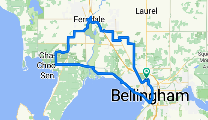
- Bellingham to Snohomish: scenic route
- Distance
- 132.5 km
- Ascent
- 994 m
- Descent
- 952 m
- Location
- Bellingham, Washington, United States of America
- Le Tour de Brewer
- Distance
- 455.3 km
- Ascent
- 3,500 m
- Descent
- 3,441 m
- Location
- Bellingham, Washington, United States of America
- to fairhaven
- Distance
- 11 km
- Ascent
- 59 m
- Descent
- 85 m
- Location
- Bellingham, Washington, United States of America
- BellinghamTrails-CornwallPark-Waterfront-Chuckanut-Interurban-PipelineTrail-Bloedel-RailroadTrail
- Distance
- 52.1 km
- Ascent
- 353 m
- Descent
- 351 m
- Location
- Bellingham, Washington, United States of America
- 1510 Franklin St, Bellingham to 15529–15531 Marine Dr, White Rock
- Distance
- 64.2 km
- Ascent
- 507 m
- Descent
- 535 m
- Location
- Bellingham, Washington, United States of America
- S. Pass/ Mosquito Route
- Distance
- 123.1 km
- Ascent
- 727 m
- Descent
- 729 m
- Location
- Bellingham, Washington, United States of America
Open it in the app