

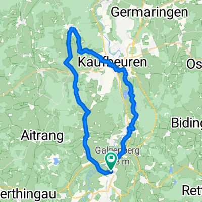
Marktoberdorf nach Füssen
A cycling route starting in Marktoberdorf, Bavaria, Germany.
Overview
About this route
Leicht hügelige Radtour über größtenteils Radwege oder verkehrsarme Nebenstraßen mit tollen Ausblicken auf die Allgäuer Alpen. Kann auch von jedem anderen Punkt der Route gestartet werden.
- -:--
- Duration
- 98.9 km
- Distance
- 489 m
- Ascent
- 492 m
- Descent
- ---
- Avg. speed
- ---
- Max. altitude

Route quality
Waytypes & surfaces along the route
Waytypes
Quiet road
41.6 km
(42 %)
Path
25.2 km
(25 %)
Surfaces
Paved
81 km
(82 %)
Unpaved
3.4 km
(3 %)
Asphalt
80.5 km
(81 %)
Gravel
2.1 km
(2 %)
Continue with Bikemap
Use, edit, or download this cycling route
You would like to ride Marktoberdorf nach Füssen or customize it for your own trip? Here is what you can do with this Bikemap route:
Free features
- Save this route as favorite or in collections
- Copy & plan your own version of this route
- Split it into stages to create a multi-day tour
- Sync your route with Garmin or Wahoo
Premium features
Free trial for 3 days, or one-time payment. More about Bikemap Premium.
- Navigate this route on iOS & Android
- Export a GPX / KML file of this route
- Create your custom printout (try it for free)
- Download this route for offline navigation
Discover more Premium features.
Get Bikemap PremiumFrom our community
Other popular routes starting in Marktoberdorf
 Dampflokrunde
- Distance
- 78.6 km
- Ascent
- 358 m
- Descent
- 361 m
- Location
- Marktoberdorf, Bavaria, Germany
 Mod - 54,8 - Mod
- Distance
- 54.8 km
- Ascent
- 275 m
- Descent
- 273 m
- Location
- Marktoberdorf, Bavaria, Germany
 MOD - Irsee
- Distance
- 36.6 km
- Ascent
- 229 m
- Descent
- 232 m
- Location
- Marktoberdorf, Bavaria, Germany
 MOD - 48 km - Wittwe-Bolte-Weiher - Kessa -MOD
- Distance
- 48.3 km
- Ascent
- 277 m
- Descent
- 277 m
- Location
- Marktoberdorf, Bavaria, Germany
 MOD-Rettenbach
- Distance
- 31.4 km
- Ascent
- 341 m
- Descent
- 340 m
- Location
- Marktoberdorf, Bavaria, Germany
 MOD-Runde
- Distance
- 47.8 km
- Ascent
- 293 m
- Descent
- 290 m
- Location
- Marktoberdorf, Bavaria, Germany
 MOD - Sachensr Bähnle - Weichberg - MOD
- Distance
- 53.5 km
- Ascent
- 504 m
- Descent
- 504 m
- Location
- Marktoberdorf, Bavaria, Germany
 Sulzschneider Forst
- Distance
- 30.1 km
- Ascent
- 190 m
- Descent
- 190 m
- Location
- Marktoberdorf, Bavaria, Germany
Open it in the app