

Sendeturm-Tour
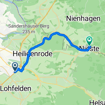
A cycling route starting in Lohfelden, Hesse, Germany.
Overview
About this route
2
From the route of the former Söhrebahn railway to the old highway bridge in the forest, over the ruins of the former chapel of Saint Juliana and the transmission tower, back to Wellerode
- -:--
- Duration
- 13.8 km
- Distance
- 292 m
- Ascent
- 211 m
- Descent
- ---
- Avg. speed
- 501 m
- Max. altitude
Izi
created this 18 years ago
Route quality
Waytypes & surfaces along the route
Waytypes
Track
10.9 km
79 %
Quiet road
1.2 km
9 %
Surfaces
Paved
1.8 km
(13 %)
Unpaved
12 km
(87 %)
Gravel
10.2 km
74 %
Asphalt
1.8 km
13 %
Continue with Bikemap
Use, edit, or download this cycling route
You would like to ride Sendeturm-Tour or customize it for your own trip? Here is what you can do with this Bikemap route:
Free features
- Save this route as favorite or in collections
- Copy & plan your own version of this route
- Sync your route with Garmin or Wahoo
Premium features
Free trial for 3 days, or one-time payment. More about Bikemap Premium.
- Navigate this route on iOS & Android
- Export a GPX / KML file of this route
- Create your custom printout (try it for free)
- Download this route for offline navigation
Discover more Premium features.
Get Bikemap PremiumFrom our community
Other popular routes starting in Lohfelden


Open it in the app