
Tour: Wien-Bratislava-Praha-Berlin-Hamburg (ridden 2016)
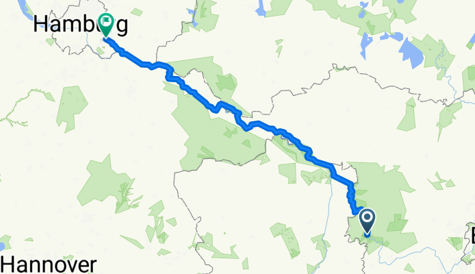
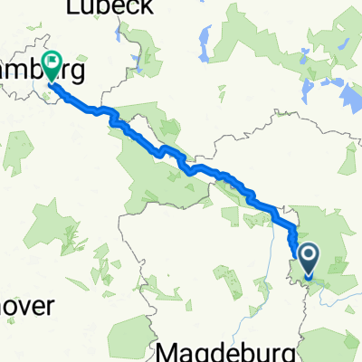
Wien-Hamburg 10/10: Premnitz - Hamburg
A cycling route starting in Premnitz, Brandenburg, Germany.
Overview
About this route
05.05.2016 (Do.) - Premnitz - Rathenow - Havelberg - Wittenberge - Cumlosen - Dömitz - Bleckede - Lauenburg / Elbe - Geesthacht - Hamburg
← (previous) Wien-Hamburg 09/10: Königs Wusterhausen - Berlin - Premnitz
Zu diesem Zeitpunkt war das meine längste Tagesstrecke mit vollbeladenem Rad. Sie führte auf den wenig anspruchsvollen, sehr gut beschilderten und gut ausgebauten Flussradwegen:
Havel-Radweg
Elbe-Radweg
GPS-Daten:
Strecke: 244,22 km
Fahrzeit: 12:31 Std
ø Geschwindigkeit: 19,50 km/h
max. Geschwindigkeit: 34,02 km/h
Wetter: sonnig
Ende der Tour!
- -:--
- Duration
- 229.6 km
- Distance
- 500 m
- Ascent
- 521 m
- Descent
- ---
- Avg. speed
- ---
- Max. altitude

Part of
Route quality
Waytypes & surfaces along the route
Waytypes
Track
103.3 km
(45 %)
Path
36.7 km
(16 %)
Surfaces
Paved
181.4 km
(79 %)
Unpaved
25.3 km
(11 %)
Asphalt
117.1 km
(51 %)
Concrete
57.4 km
(25 %)
Continue with Bikemap
Use, edit, or download this cycling route
You would like to ride Wien-Hamburg 10/10: Premnitz - Hamburg or customize it for your own trip? Here is what you can do with this Bikemap route:
Free features
- Save this route as favorite or in collections
- Copy & plan your own version of this route
- Split it into stages to create a multi-day tour
- Sync your route with Garmin or Wahoo
Premium features
Free trial for 3 days, or one-time payment. More about Bikemap Premium.
- Navigate this route on iOS & Android
- Export a GPX / KML file of this route
- Create your custom printout (try it for free)
- Download this route for offline navigation
Discover more Premium features.
Get Bikemap PremiumFrom our community
Other popular routes starting in Premnitz
 Havellandradtour 2.Tag (11.5.2013)
- Distance
- 78.9 km
- Ascent
- 131 m
- Descent
- 125 m
- Location
- Premnitz, Brandenburg, Germany
 Trainingsstrecke Straße
- Distance
- 25.2 km
- Ascent
- 81 m
- Descent
- 83 m
- Location
- Premnitz, Brandenburg, Germany
 16.07.31 Milow-Waren
- Distance
- 162 km
- Ascent
- 283 m
- Descent
- 239 m
- Location
- Premnitz, Brandenburg, Germany
 Rund um Rathenow - Teil 2
- Distance
- 45.8 km
- Ascent
- 120 m
- Descent
- 118 m
- Location
- Premnitz, Brandenburg, Germany
 Milower Land Kiefernweg Rundfahrt
- Distance
- 33.2 km
- Ascent
- 64 m
- Descent
- 65 m
- Location
- Premnitz, Brandenburg, Germany
 BUGA2015LOOTZ-1
- Distance
- 194.2 km
- Ascent
- 128 m
- Descent
- 129 m
- Location
- Premnitz, Brandenburg, Germany
 Wien-Hamburg 10/10: Premnitz - Hamburg
- Distance
- 229.6 km
- Ascent
- 500 m
- Descent
- 521 m
- Location
- Premnitz, Brandenburg, Germany
 Von Kützkow über Bahnitz, Milow und Premnitz zurück nach Pritzerbe
- Distance
- 28.1 km
- Ascent
- 77 m
- Descent
- 78 m
- Location
- Premnitz, Brandenburg, Germany
Open it in the app