
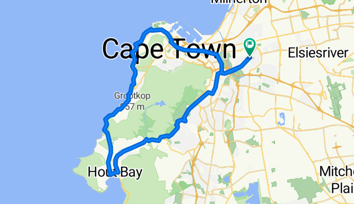
56km - Pinelands, Hout Bay, Camps Bay, Pinelands
A cycling route starting in Rosebank, Western Cape, Republic of South Africa.
Overview
About this route
Pinelands, Constantia Neck, Hout Bay, Camps Bay, Seapoint, Pinlands.
- -:--
- Duration
- 56.3 km
- Distance
- 470 m
- Ascent
- 470 m
- Descent
- ---
- Avg. speed
- ---
- Max. altitude
Route quality
Waytypes & surfaces along the route
Waytypes
Quiet road
11.3 km
(20 %)
Cycleway
3.9 km
(7 %)
Surfaces
Paved
53.5 km
(95 %)
Asphalt
52.4 km
(93 %)
Paved (undefined)
1.1 km
(2 %)
Undefined
2.8 km
(5 %)
Continue with Bikemap
Use, edit, or download this cycling route
You would like to ride 56km - Pinelands, Hout Bay, Camps Bay, Pinelands or customize it for your own trip? Here is what you can do with this Bikemap route:
Free features
- Save this route as favorite or in collections
- Copy & plan your own version of this route
- Sync your route with Garmin or Wahoo
Premium features
Free trial for 3 days, or one-time payment. More about Bikemap Premium.
- Navigate this route on iOS & Android
- Export a GPX / KML file of this route
- Create your custom printout (try it for free)
- Download this route for offline navigation
Discover more Premium features.
Get Bikemap PremiumFrom our community
Other popular routes starting in Rosebank
 530 navigation test
- Distance
- 6.8 km
- Ascent
- 13 m
- Descent
- 23 m
- Location
- Rosebank, Western Cape, Republic of South Africa
 Newlands round to Plumstead
- Distance
- 33.1 km
- Ascent
- 167 m
- Descent
- 165 m
- Location
- Rosebank, Western Cape, Republic of South Africa
 Around Cape Point
- Distance
- 146 km
- Ascent
- 869 m
- Descent
- 869 m
- Location
- Rosebank, Western Cape, Republic of South Africa
 SouthAfrica_2020
- Distance
- 1,164.7 km
- Ascent
- 3,424 m
- Descent
- 3,416 m
- Location
- Rosebank, Western Cape, Republic of South Africa
 Kirstenbosch Loop
- Distance
- 29.9 km
- Ascent
- 252 m
- Descent
- 249 m
- Location
- Rosebank, Western Cape, Republic of South Africa
 Recovered Route
- Distance
- 7.2 km
- Ascent
- 86 m
- Descent
- 53 m
- Location
- Rosebank, Western Cape, Republic of South Africa
 Voortrekker Road, Cape Town to Old Oak Road, Cape Town
- Distance
- 17.2 km
- Ascent
- 167 m
- Descent
- 65 m
- Location
- Rosebank, Western Cape, Republic of South Africa
 Station Road 5, Cape Town to Campground Road ERF97101, Cape Town
- Distance
- 4.6 km
- Ascent
- 36 m
- Descent
- 33 m
- Location
- Rosebank, Western Cape, Republic of South Africa
Open it in the app