

Donau-Bodensee
UDB03_Sigmaringen-Tuttlingen
A cycling route starting in Sigmaringen, Baden-Wurttemberg, Germany.
Overview
About this route
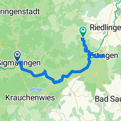
Start: Sigmaringen
Über: Dietfurt - Gutenstein - Thiergarten - Ziegelhütte - Mülheim a.d.Donau
Ziel: Tuttlingen
- -:--
- Duration
- 57.6 km
- Distance
- 312 m
- Ascent
- 261 m
- Descent
- ---
- Avg. speed
- 653 m
- Max. altitude

Part of
9 stages
Route quality
Waytypes & surfaces along the route
Waytypes
Track
25.2 km
(44 %)
Path
10.5 km
(18 %)
Surfaces
Paved
42.6 km
(74 %)
Unpaved
13.6 km
(24 %)
Asphalt
37.7 km
(65 %)
Gravel
10.1 km
(17 %)
Route highlights
Points of interest along the route

Point of interest after 4.9 km
Kloster Inzigkofen

Point of interest after 9.4 km
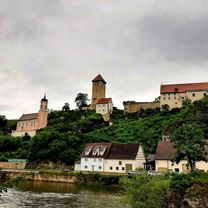
Burgruine Dietfurt

Point of interest after 12.7 km
Schloss Gutenstein

Point of interest after 31 km
Benediktiner Erzabtei St. Martin / Kloster Beuron

Point of interest after 44.9 km
Klosterruine Maria Hilf

Point of interest after 47.8 km
Schloss der Herren von Enzberg (Schloss Mülheim)

Point of interest after 57 km
Burgruine Honberg
Continue with Bikemap
Use, edit, or download this cycling route
You would like to ride UDB03_Sigmaringen-Tuttlingen or customize it for your own trip? Here is what you can do with this Bikemap route:
Free features
- Save this route as favorite or in collections
- Copy & plan your own version of this route
- Sync your route with Garmin or Wahoo
Premium features
Free trial for 3 days, or one-time payment. More about Bikemap Premium.
- Navigate this route on iOS & Android
- Export a GPX / KML file of this route
- Create your custom printout (try it for free)
- Download this route for offline navigation
Discover more Premium features.
Get Bikemap PremiumFrom our community
Other popular routes starting in Sigmaringen
 UDB03_Sigmaringen-Tuttlingen
- Distance
- 57.6 km
- Ascent
- 312 m
- Descent
- 261 m
- Location
- Sigmaringen, Baden-Wurttemberg, Germany
 Donauradweg DE 3
- Distance
- 82.6 km
- Ascent
- 277 m
- Descent
- 369 m
- Location
- Sigmaringen, Baden-Wurttemberg, Germany
 Tour 1 - Schmeiental-Tour
- Distance
- 21.6 km
- Ascent
- 375 m
- Descent
- 375 m
- Location
- Sigmaringen, Baden-Wurttemberg, Germany
 Sigmaringen, Donauradweg bis Mengen, Zielfinger Seen, über Wildpark Josefslust zurück nach Sigmaringen.
- Distance
- 31.9 km
- Ascent
- 1,498 m
- Descent
- 1,494 m
- Location
- Sigmaringen, Baden-Wurttemberg, Germany
 Sigmaringen Radfahren
- Distance
- 30.8 km
- Ascent
- 178 m
- Descent
- 178 m
- Location
- Sigmaringen, Baden-Wurttemberg, Germany
 19. Sigmaringen-Riedsee/Donaueschingen (izvor Dunava)
- Distance
- 86.6 km
- Ascent
- 1,358 m
- Descent
- 1,256 m
- Location
- Sigmaringen, Baden-Wurttemberg, Germany
 Tag 2 Sigmaringen nach Riedheim
- Distance
- 138 km
- Ascent
- 1,026 m
- Descent
- 1,150 m
- Location
- Sigmaringen, Baden-Wurttemberg, Germany
 From Sigmaringen to Altheim
- Distance
- 38.7 km
- Ascent
- 269 m
- Descent
- 279 m
- Location
- Sigmaringen, Baden-Wurttemberg, Germany
Open it in the app