

7 Hügel mit einmaligem Panorama
A cycling route starting in Bolligen, Canton of Bern, Switzerland.
Overview
About this route
<span style="font-size: 12.0pt; line-height: 115%; font-family: "Cambria","serif"; mso-ascii-theme-font: major-latin; mso-fareast-font-family: "Times New Roman"; mso-hansi-theme-font: major-latin; mso-bidi-font-family: "Times New Roman"; color: #535353; mso-fareast-language: DE-CH;">Start beim Sternenplatz in Bolligen, Deisswil, Gümligental, Dentenberg, Langenloh-Rüfenacht, Wislen-Worb, Gysenstein, Ballenbühl, Grosshöchstetten, Blasen, Arnisäge, Gumm, Walkringen,</span><span style="font-size: 12.0pt; line-height: 115%; font-family: "Cambria","serif"; mso-ascii-theme-font: major-latin; mso-fareast-font-family: "Times New Roman"; mso-hansi-theme-font: major-latin; mso-bidi-font-family: "Times New Roman"; color: black; mso-fareast-language: DE-CH;">Mänziwilegg</span><span style="font-size: 12.0pt; line-height: 115%; font-family: "Cambria","serif"; mso-ascii-theme-font: major-latin; mso-fareast-font-family: "Times New Roman"; mso-hansi-theme-font: major-latin; mso-bidi-font-family: "Times New Roman"; color: #535353; mso-fareast-language: DE-CH;">, Boll, Ferenberg, Bolligen.</span>
<span style="font-size: 12.0pt; font-family: "Cambria","serif"; mso-ascii-theme-font: major-latin; mso-fareast-font-family: "Times New Roman"; mso-hansi-theme-font: major-latin; mso-bidi-font-family: "Times New Roman"; color: black; mso-fareast-language: DE-CH;">Die Tour führt vorwiegend über Asphalt, ist somit auch bei schlechterem Wetter gut befahrbar. Anstiege zum Teil steil (Ballenbühl, von Lütiwil nach Gumm ca 25% Steigung , Asphalt)</span> <table class="MsoNormalTable " style="border-collapse: collapse; mso-yfti-tbllook: 1184; mso-padding-alt: 0cm 0cm 0cm 0cm;" border="0" cellspacing="0" cellpadding="0"> <tbody> <tr style="mso-yfti-irow: 0; mso-yfti-firstrow: yes; mso-yfti-lastrow: yes;"> <td style="width: .3pt; background: white; padding: 0cm 0cm 14.4pt 0cm;" width="0" valign="top"></td> <td style="background: white; padding: 0cm 0cm 0cm 0cm;" valign="top"></td> </tr> </tbody> </table>
<span style="font-size: 12.0pt; line-height: 115%; font-family: "Cambria","serif"; mso-ascii-theme-font: major-latin; mso-hansi-theme-font: major-latin;"> </span>
- -:--
- Duration
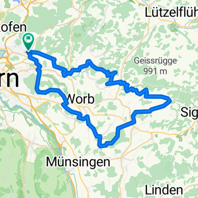
- 51.6 km
- Distance
- 1,291 m
- Ascent
- 1,291 m
- Descent
- ---
- Avg. speed
- ---
- Max. altitude

Route quality
Waytypes & surfaces along the route
Waytypes
Quiet road
31 km
(60 %)
Track
12.5 km
(24 %)
Surfaces
Paved
25.4 km
(49 %)
Unpaved
5.2 km
(10 %)
Asphalt
19 km
(37 %)
Paved (undefined)
6.4 km
(12 %)
Continue with Bikemap
Use, edit, or download this cycling route
You would like to ride 7 Hügel mit einmaligem Panorama or customize it for your own trip? Here is what you can do with this Bikemap route:
Free features
- Save this route as favorite or in collections
- Copy & plan your own version of this route
- Sync your route with Garmin or Wahoo
Premium features
Free trial for 3 days, or one-time payment. More about Bikemap Premium.
- Navigate this route on iOS & Android
- Export a GPX / KML file of this route
- Create your custom printout (try it for free)
- Download this route for offline navigation
Discover more Premium features.
Get Bikemap PremiumFrom our community
Other popular routes starting in Bolligen
 7 Hügel mit einmaligem Panorama
- Distance
- 51.6 km
- Ascent
- 1,291 m
- Descent
- 1,291 m
- Location
- Bolligen, Canton of Bern, Switzerland
 Ittigen-Kirchlindach-Münchenbuchsee-Ittigen
- Distance
- 23.6 km
- Ascent
- 193 m
- Descent
- 192 m
- Location
- Bolligen, Canton of Bern, Switzerland
 Ittigen-Krauchtal-Hindelbank-Ittigen
- Distance
- 23.4 km
- Ascent
- 222 m
- Descent
- 229 m
- Location
- Bolligen, Canton of Bern, Switzerland
 Ittigen-Flugbrunnen-Worb
- Distance
- 28.9 km
- Ascent
- 273 m
- Descent
- 245 m
- Location
- Bolligen, Canton of Bern, Switzerland
 Winterfahrt (bei weichem Schnee) zum Bantiger
- Distance
- 20.5 km
- Ascent
- 616 m
- Descent
- 617 m
- Location
- Bolligen, Canton of Bern, Switzerland
 Burgdorf-Lyssach Runde
- Distance
- 32.5 km
- Ascent
- 355 m
- Descent
- 355 m
- Location
- Bolligen, Canton of Bern, Switzerland
 Mittwoch Cher Bolligen -wikartswil- Bolligen
- Distance
- 39.9 km
- Ascent
- 464 m
- Descent
- 464 m
- Location
- Bolligen, Canton of Bern, Switzerland
 Ittigen-Bühren-Ittigen
- Distance
- 60.9 km
- Ascent
- 369 m
- Descent
- 369 m
- Location
- Bolligen, Canton of Bern, Switzerland
Open it in the app