

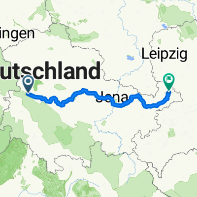
Wege zum Rennsteig
A cycling route starting in Eisenach, Free State of Thuringia, Germany.
Overview
About this route
Diese Route ist eigentlich gar keine Radtour. Wenn man sich die GPX-Datei herunterlädt, hat man so was ähnliches wie eine Fahrradkarte. Man findet unzählige Wege von Eisenach und dem Eltetal zum Rennsteig zwischen Vachaer Stein und Hohe Sonne. Es gibt natürlich noch viel mehr Wege. Aber die Ausgewählten sind alle recht gut befahrbar. Trails usw. muss dann jeder selbst finden.
- -:--
- Duration
- 83.2 km
- Distance
- 1,884 m
- Ascent
- 1,883 m
- Descent
- ---
- Avg. speed
- ---
- Max. altitude
Route quality
Waytypes & surfaces along the route
Waytypes
Track
60 km
(72 %)
Quiet road
7.9 km
(9 %)
Surfaces
Paved
10.8 km
(13 %)
Unpaved
63.4 km
(76 %)
Gravel
39.1 km
(47 %)
Ground
14.4 km
(17 %)
Continue with Bikemap
Use, edit, or download this cycling route
You would like to ride Wege zum Rennsteig or customize it for your own trip? Here is what you can do with this Bikemap route:
Free features
- Save this route as favorite or in collections
- Copy & plan your own version of this route
- Split it into stages to create a multi-day tour
- Sync your route with Garmin or Wahoo
Premium features
Free trial for 3 days, or one-time payment. More about Bikemap Premium.
- Navigate this route on iOS & Android
- Export a GPX / KML file of this route
- Create your custom printout (try it for free)
- Download this route for offline navigation
Discover more Premium features.
Get Bikemap PremiumFrom our community
Other popular routes starting in Eisenach
 kurze Tour
- Distance
- 17.3 km
- Ascent
- 213 m
- Descent
- 205 m
- Location
- Eisenach, Free State of Thuringia, Germany
 Thüringer Radfernwege - 11 - Thüringer Städtekette - D-Route 4
- Distance
- 233.6 km
- Ascent
- 1,500 m
- Descent
- 1,543 m
- Location
- Eisenach, Free State of Thuringia, Germany
 07.Wer.Eisen.-Philipst.
- Distance
- 195.8 km
- Ascent
- 2,079 m
- Descent
- 1,479 m
- Location
- Eisenach, Free State of Thuringia, Germany
 Westroute Thüringer Wald
- Distance
- 96 km
- Ascent
- 1,150 m
- Descent
- 1,150 m
- Location
- Eisenach, Free State of Thuringia, Germany
 Eisenach -Kerspenhausen
- Distance
- 79.7 km
- Ascent
- 537 m
- Descent
- 549 m
- Location
- Eisenach, Free State of Thuringia, Germany
 Zentraler Thüringer Wald
- Distance
- 99.9 km
- Ascent
- 1,260 m
- Descent
- 1,260 m
- Location
- Eisenach, Free State of Thuringia, Germany
 Eisenach-Gotha
- Distance
- 43.2 km
- Ascent
- 272 m
- Descent
- 190 m
- Location
- Eisenach, Free State of Thuringia, Germany
 Goethestraße, Eisenach nach Planstraße, Amt Creuzburg
- Distance
- 26.1 km
- Ascent
- 394 m
- Descent
- 431 m
- Location
- Eisenach, Free State of Thuringia, Germany
Open it in the app