
MRT Road - Gravel Mix
A cycling route starting in Millington, Tennessee, United States.
Overview
About this route
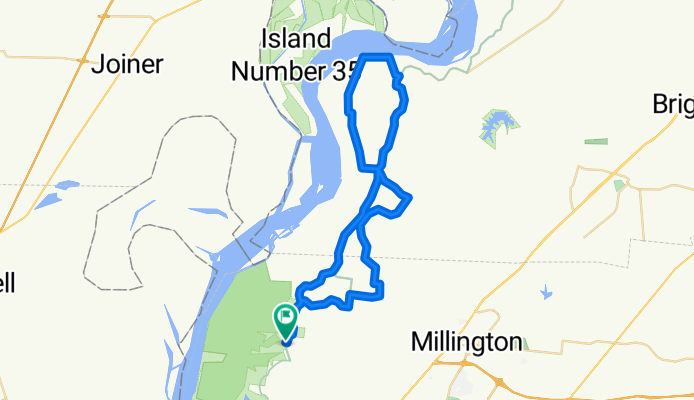
Start at Shelby Forrest Vistors Center. I suggest doing counter-clockwise to avoid steep climbs
- -:--
- Duration
- 57.8 km
- Distance
- 167 m
- Ascent
- 167 m
- Descent
- ---
- Avg. speed
- ---
- Max. altitude

Route quality
Waytypes & surfaces along the route
Waytypes
Quiet road
35.8 km
(62 %)
Road
22 km
(38 %)
Surfaces
Paved
4 km
(7 %)
Unpaved
4.6 km
(8 %)
Gravel
4.6 km
(8 %)
Paved (undefined)
3.5 km
(6 %)
Continue with Bikemap
Use, edit, or download this cycling route
You would like to ride MRT Road - Gravel Mix or customize it for your own trip? Here is what you can do with this Bikemap route:
Free features
- Save this route as favorite or in collections
- Copy & plan your own version of this route
- Sync your route with Garmin or Wahoo
Premium features
Free trial for 3 days, or one-time payment. More about Bikemap Premium.
- Navigate this route on iOS & Android
- Export a GPX / KML file of this route
- Create your custom printout (try it for free)
- Download this route for offline navigation
Discover more Premium features.
Get Bikemap PremiumFrom our community
Other popular routes starting in Millington
 MRT Road - Gravel Mix
- Distance
- 57.8 km
- Ascent
- 167 m
- Descent
- 167 m
- Location
- Millington, Tennessee, United States
 Shelby Forrest 27.5
- Distance
- 44 km
- Ascent
- 158 m
- Descent
- 156 m
- Location
- Millington, Tennessee, United States
 State Park Entrance 968, Millington to State Park Entrance 955, Millington
- Distance
- 26.6 km
- Ascent
- 125 m
- Descent
- 127 m
- Location
- Millington, Tennessee, United States
 Shelby Forest 23
- Distance
- 36.7 km
- Ascent
- 109 m
- Descent
- 112 m
- Location
- Millington, Tennessee, United States
 Shelby Forest 20
- Distance
- 32.9 km
- Ascent
- 137 m
- Descent
- 138 m
- Location
- Millington, Tennessee, United States
 Loop Ride Woodstock Area - Rural
- Distance
- 20.3 km
- Ascent
- 174 m
- Descent
- 165 m
- Location
- Millington, Tennessee, United States
 Shelby forest cruise
- Distance
- 26.5 km
- Ascent
- 149 m
- Descent
- 173 m
- Location
- Millington, Tennessee, United States
 Mississippi River Trail: Millington to Brighton
- Distance
- 38.2 km
- Ascent
- 227 m
- Descent
- 210 m
- Location
- Millington, Tennessee, United States
Open it in the app