C 2014
- 102.6 km
- 1,094 m
- 1,094 m
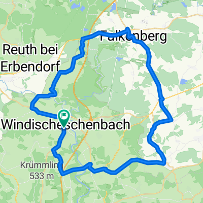
- Windischeschenbach, Bavaria, Germany
A cycling route starting in Windischeschenbach, Bavaria, Germany.
Overview
-W-Eschenbach
VP Erbendorf: 32 km
VP Falkenberg: 59 km
-Ziel W-Eschenback: 76 km
ab Friedenfels Voitenthann und Kornthann nach Wiesau dort Einmdg. in C-Strecke. Weiter auf C über Falkenberg (2. VP) ins Ziel
created this 15 years ago
Continue with Bikemap
You would like to ride D 2013 or customize it for your own trip? Here is what you can do with this Bikemap route:
Free trial for 3 days, or one-time payment. More about Bikemap Premium.
Discover more Premium features.
Get Bikemap PremiumFrom our community
Open it in the app