

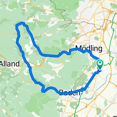
Guntramsdorf - Hochrotherd Runde
A cycling route starting in Guntramsdorf, Lower Austria, Austria.
Overview
About this route
Guntramsdorf - Mödling - Hochrotherd - Alland - Helenental - Baden - Guntramsdorf
- -:--
- Duration
- 56.3 km
- Distance
- 364 m
- Ascent
- 362 m
- Descent
- ---
- Avg. speed
- ---
- Avg. speed

Route quality
Waytypes & surfaces along the route
Waytypes
Busy road
14.2 km
(25 %)
Cycleway
11.9 km
(21 %)
Surfaces
Paved
45 km
(80 %)
Unpaved
3.1 km
(6 %)
Asphalt
43.2 km
(77 %)
Gravel
1.4 km
(2 %)
Continue with Bikemap
Use, edit, or download this cycling route
You would like to ride Guntramsdorf - Hochrotherd Runde or customize it for your own trip? Here is what you can do with this Bikemap route:
Free features
- Save this route as favorite or in collections
- Copy & plan your own version of this route
- Sync your route with Garmin or Wahoo
Premium features
Free trial for 3 days, or one-time payment. More about Bikemap Premium.
- Navigate this route on iOS & Android
- Export a GPX / KML file of this route
- Create your custom printout (try it for free)
- Download this route for offline navigation
Discover more Premium features.
Get Bikemap PremiumFrom our community
Other popular routes starting in Guntramsdorf
 22.08.2018
- Distance
- 39.8 km
- Ascent
- 505 m
- Descent
- 505 m
- Location
- Guntramsdorf, Lower Austria, Austria
 Guntramsdorf - Hochrotherd Runde
- Distance
- 56.3 km
- Ascent
- 364 m
- Descent
- 362 m
- Location
- Guntramsdorf, Lower Austria, Austria
 Runde um den Anninger
- Distance
- 42.3 km
- Ascent
- 256 m
- Descent
- 256 m
- Location
- Guntramsdorf, Lower Austria, Austria
 kurze Runde um den Anninger
- Distance
- 34.3 km
- Ascent
- 234 m
- Descent
- 234 m
- Location
- Guntramsdorf, Lower Austria, Austria
 Guntramsdorf Husarentempel Waldabfahrt Goldene Stiege
- Distance
- 20.3 km
- Ascent
- 452 m
- Descent
- 451 m
- Location
- Guntramsdorf, Lower Austria, Austria
 Neufeld an der Leitha
- Distance
- 80.3 km
- Ascent
- 298 m
- Descent
- 299 m
- Location
- Guntramsdorf, Lower Austria, Austria
 Weingartenradweg Thermenradweg
- Distance
- 34.5 km
- Ascent
- 162 m
- Descent
- 159 m
- Location
- Guntramsdorf, Lower Austria, Austria
 Anninger - Vierjochkogel
- Distance
- 20.1 km
- Ascent
- 587 m
- Descent
- 583 m
- Location
- Guntramsdorf, Lower Austria, Austria
Open it in the app