

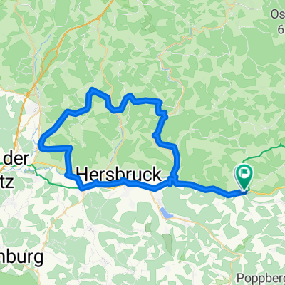
Wei-Hartenstein-Wei
A cycling route starting in Weigendorf, Bavaria, Germany.
Overview
About this route
Wei-Fischbrunn-Alfalter-Stöppach-Hohenstein-Rupprechtstegen-Hartenstein-Hirschbach-Etzelwang-Wei
- -:--
- Duration
- 49.1 km
- Distance
- 712 m
- Ascent
- 713 m
- Descent
- ---
- Avg. speed
- ---
- Max. altitude
Route quality
Waytypes & surfaces along the route
Waytypes
Quiet road
24.5 km
(50 %)
Track
14.2 km
(29 %)
Surfaces
Paved
27.5 km
(56 %)
Unpaved
10.3 km
(21 %)
Asphalt
25 km
(51 %)
Gravel
9.3 km
(19 %)
Continue with Bikemap
Use, edit, or download this cycling route
You would like to ride Wei-Hartenstein-Wei or customize it for your own trip? Here is what you can do with this Bikemap route:
Free features
- Save this route as favorite or in collections
- Copy & plan your own version of this route
- Sync your route with Garmin or Wahoo
Premium features
Free trial for 3 days, or one-time payment. More about Bikemap Premium.
- Navigate this route on iOS & Android
- Export a GPX / KML file of this route
- Create your custom printout (try it for free)
- Download this route for offline navigation
Discover more Premium features.
Get Bikemap PremiumFrom our community
Other popular routes starting in Weigendorf
 5 Flüsse Radweg Teil 2
- Distance
- 47.9 km
- Ascent
- 96 m
- Descent
- 211 m
- Location
- Weigendorf, Bavaria, Germany
 Lichtenegg 1, Birgland nach Lichtenegg 1, Birgland
- Distance
- 8 km
- Ascent
- 246 m
- Descent
- 242 m
- Location
- Weigendorf, Bavaria, Germany
 Wei_Kersbach_Morsbrunn_Düsselbach
- Distance
- 51.3 km
- Ascent
- 545 m
- Descent
- 564 m
- Location
- Weigendorf, Bavaria, Germany
 Wei-Hartenstein-Wei
- Distance
- 49.1 km
- Ascent
- 712 m
- Descent
- 713 m
- Location
- Weigendorf, Bavaria, Germany
 Hartmannshof-Happurg-Lichtenegg-Lehenhammer
- Distance
- 43.5 km
- Ascent
- 958 m
- Descent
- 957 m
- Location
- Weigendorf, Bavaria, Germany
 wolfstein
- Distance
- 32.7 km
- Ascent
- 357 m
- Descent
- 298 m
- Location
- Weigendorf, Bavaria, Germany
 Haunritz_Lichtenegg_Kronberg_Högen
- Distance
- 16.4 km
- Ascent
- 493 m
- Descent
- 487 m
- Location
- Weigendorf, Bavaria, Germany
 D_Bayern_Hartmannshof-Lichteneck-Wurmrausch-Tannlohe-Högen_16.8km-410hm
- Distance
- 16.9 km
- Ascent
- 399 m
- Descent
- 396 m
- Location
- Weigendorf, Bavaria, Germany
Open it in the app