

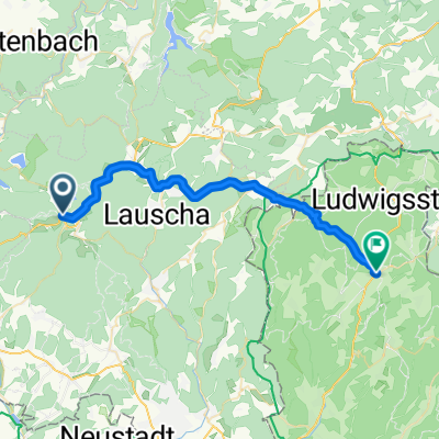
Talsperre Goldisthal tangieren
A cycling route starting in Steinheid, Thuringia, Germany.
Overview
About this route
and back via Friedrichshöhe (food available there)
- -:--
- Duration
- 12.2 km
- Distance
- 358 m
- Ascent
- 358 m
- Descent
- ---
- Avg. speed
- ---
- Max. altitude
Continue with Bikemap
Use, edit, or download this cycling route
You would like to ride Talsperre Goldisthal tangieren or customize it for your own trip? Here is what you can do with this Bikemap route:
Free features
- Save this route as favorite or in collections
- Copy & plan your own version of this route
- Sync your route with Garmin or Wahoo
Premium features
Free trial for 3 days, or one-time payment. More about Bikemap Premium.
- Navigate this route on iOS & Android
- Export a GPX / KML file of this route
- Create your custom printout (try it for free)
- Download this route for offline navigation
Discover more Premium features.
Get Bikemap PremiumFrom our community
Other popular routes starting in Steinheid
 Skiwanderung Werraquelle
- Distance
- 19.1 km
- Ascent
- 259 m
- Descent
- 258 m
- Location
- Steinheid, Thuringia, Germany
 KT5: 6+7_Spechtsbrunn - Brennergrün
- Distance
- 29.5 km
- Ascent
- 345 m
- Descent
- 458 m
- Location
- Steinheid, Thuringia, Germany
 Alte Straße 15, Neuhaus am Rennweg nach Ulmenweg 17, Weitramsdorf
- Distance
- 38.1 km
- Ascent
- 504 m
- Descent
- 914 m
- Location
- Steinheid, Thuringia, Germany
 Langlaufroute Friedrichshöhe
- Distance
- 21.2 km
- Ascent
- 225 m
- Descent
- 225 m
- Location
- Steinheid, Thuringia, Germany
 Großes Tor - Stausee Scheibe mit Umrundung
- Distance
- 25.5 km
- Ascent
- 297 m
- Descent
- 421 m
- Location
- Steinheid, Thuringia, Germany
 Wetzhausen Saalfeld
- Distance
- 111 km
- Ascent
- 352 m
- Descent
- 849 m
- Location
- Steinheid, Thuringia, Germany
 Lengthy Donnerstag Ride In Sachsenbrunn
- Distance
- 22 km
- Ascent
- 317 m
- Descent
- 319 m
- Location
- Steinheid, Thuringia, Germany
 2018-02-24 LL Steinheid
- Distance
- 10.2 km
- Ascent
- 128 m
- Descent
- 127 m
- Location
- Steinheid, Thuringia, Germany
Open it in the app