

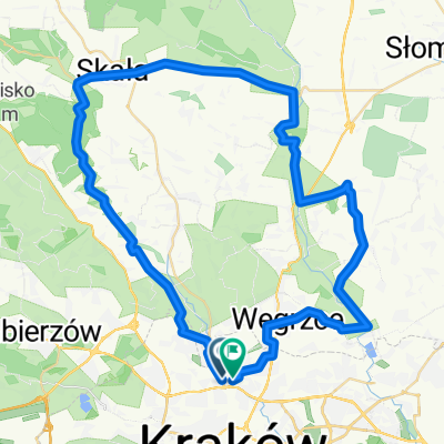
Dolina Prądnika
A cycling route starting in Zielonki, Lesser Poland Voivodeship, Poland.
Overview
About this route
Not too long but very pleasant
Climbs:
1/Łokietka-long and medium
2/Giebłutów-short and medium
3/Skała-Cianowice-medium-steep
4/Pękowice-short and steep
Route with amazing views in the Prądnika valley
90% asphalted. The rest is sand and stones (descent from Giebłutów and part of the route in the Ojców National Park)
There is a possibility to significantly complicate the ride by going not through the valley but along the slopes, but then you need to prepare for quite steep and long climbs.
- -:--
- Duration
- 44.4 km
- Distance
- 421 m
- Ascent
- 421 m
- Descent
- ---
- Avg. speed
- ---
- Max. altitude
Continue with Bikemap
Use, edit, or download this cycling route
You would like to ride Dolina Prądnika or customize it for your own trip? Here is what you can do with this Bikemap route:
Free features
- Save this route as favorite or in collections
- Copy & plan your own version of this route
- Sync your route with Garmin or Wahoo
Premium features
Free trial for 3 days, or one-time payment. More about Bikemap Premium.
- Navigate this route on iOS & Android
- Export a GPX / KML file of this route
- Create your custom printout (try it for free)
- Download this route for offline navigation
Discover more Premium features.
Get Bikemap PremiumFrom our community
Other popular routes starting in Zielonki
 Bibice - Zielonki
- Distance
- 2.8 km
- Ascent
- 38 m
- Descent
- 31 m
- Location
- Zielonki, Lesser Poland Voivodeship, Poland
 Dolina Prądnika
- Distance
- 44.4 km
- Ascent
- 421 m
- Descent
- 421 m
- Location
- Zielonki, Lesser Poland Voivodeship, Poland
 pętelka treningowa
- Distance
- 47.6 km
- Ascent
- 634 m
- Descent
- 636 m
- Location
- Zielonki, Lesser Poland Voivodeship, Poland
 Zimowo super zamrożone.
- Distance
- 54 km
- Ascent
- 489 m
- Descent
- 487 m
- Location
- Zielonki, Lesser Poland Voivodeship, Poland
 SkalaPetelka
- Distance
- 40.7 km
- Ascent
- 275 m
- Descent
- 276 m
- Location
- Zielonki, Lesser Poland Voivodeship, Poland
 Strzelców, Kraków do Ojców, Skała
- Distance
- 21.3 km
- Ascent
- 475 m
- Descent
- 325 m
- Location
- Zielonki, Lesser Poland Voivodeship, Poland
 Szlak czerwony w gminie zielonki
- Distance
- 32.6 km
- Ascent
- 345 m
- Descent
- 345 m
- Location
- Zielonki, Lesser Poland Voivodeship, Poland
 Dolina Dłubni
- Distance
- 59.3 km
- Ascent
- 826 m
- Descent
- 830 m
- Location
- Zielonki, Lesser Poland Voivodeship, Poland
Open it in the app