

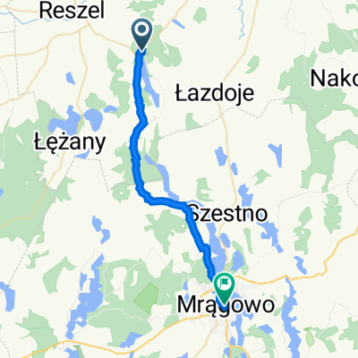
vezławki
A cycling route starting in Reszel, Warmian-Masurian Voivodeship, Poland.
Overview
About this route
- 1 h 17 min
- Duration
- 18.6 km
- Distance
- 211 m
- Ascent
- 215 m
- Descent
- 14.5 km/h
- Avg. speed
- ---
- Max. altitude

Route photos


Route quality
Waytypes & surfaces along the route
Waytypes
Quiet road
9.4 km
(50 %)
Road
4.9 km
(26 %)
Surfaces
Paved
3.3 km
(18 %)
Unpaved
11.6 km
(62 %)
Ground
4.2 km
(23 %)
Loose gravel
3.3 km
(18 %)
Continue with Bikemap
Use, edit, or download this cycling route
You would like to ride vezławki or customize it for your own trip? Here is what you can do with this Bikemap route:
Free features
- Save this route as favorite or in collections
- Copy & plan your own version of this route
- Sync your route with Garmin or Wahoo
Premium features
Free trial for 3 days, or one-time payment. More about Bikemap Premium.
- Navigate this route on iOS & Android
- Export a GPX / KML file of this route
- Create your custom printout (try it for free)
- Download this route for offline navigation
Discover more Premium features.
Get Bikemap PremiumFrom our community
Other popular routes starting in Reszel
 07/07 Swieta Lipka - Wilkasy
- Distance
- 51 km
- Ascent
- 186 m
- Descent
- 198 m
- Location
- Reszel, Warmian-Masurian Voivodeship, Poland
 UH CMA D07 Reszel - Mrągowo - Krutyń 55km
- Distance
- 54.5 km
- Ascent
- 228 m
- Descent
- 203 m
- Location
- Reszel, Warmian-Masurian Voivodeship, Poland
 07/06 Runde um Swieta Lipka
- Distance
- 26.1 km
- Ascent
- 125 m
- Descent
- 124 m
- Location
- Reszel, Warmian-Masurian Voivodeship, Poland
 6.diena
- Distance
- 57.8 km
- Ascent
- 228 m
- Descent
- 229 m
- Location
- Reszel, Warmian-Masurian Voivodeship, Poland
 vezławki
- Distance
- 18.6 km
- Ascent
- 211 m
- Descent
- 215 m
- Location
- Reszel, Warmian-Masurian Voivodeship, Poland
 Święta Lipka 28, Reszel a Mrongowiusza 3, Mragowo
- Distance
- 22.9 km
- Ascent
- 377 m
- Descent
- 366 m
- Location
- Reszel, Warmian-Masurian Voivodeship, Poland
 W Jagiełły 4, Reszel a Święta Lipka 26E, Reszel
- Distance
- 7.4 km
- Ascent
- 74 m
- Descent
- 62 m
- Location
- Reszel, Warmian-Masurian Voivodeship, Poland
 Reszel - Kal
- Distance
- 62.6 km
- Ascent
- 359 m
- Descent
- 361 m
- Location
- Reszel, Warmian-Masurian Voivodeship, Poland
Open it in the app