

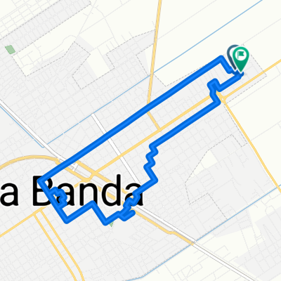
Ruta desde Ruta Provincial 51, La Banda
A cycling route starting in La Banda, Santiago del Estero Province, Argentina.
Overview
About this route
- 24 min
- Duration
- 8.6 km
- Distance
- 13 m
- Ascent
- 9 m
- Descent
- 21.2 km/h
- Avg. speed
- ---
- Max. altitude

Route quality
Waytypes & surfaces along the route
Waytypes
Quiet road
4 km
(47 %)
Road
3 km
(35 %)
Surfaces
Paved
1.3 km
(15 %)
Paved (undefined)
1.3 km
(15 %)
Undefined
7.3 km
(85 %)
Continue with Bikemap
Use, edit, or download this cycling route
You would like to ride Ruta desde Ruta Provincial 51, La Banda or customize it for your own trip? Here is what you can do with this Bikemap route:
Free features
- Save this route as favorite or in collections
- Copy & plan your own version of this route
- Sync your route with Garmin or Wahoo
Premium features
Free trial for 3 days, or one-time payment. More about Bikemap Premium.
- Navigate this route on iOS & Android
- Export a GPX / KML file of this route
- Create your custom printout (try it for free)
- Download this route for offline navigation
Discover more Premium features.
Get Bikemap PremiumFrom our community
Other popular routes starting in La Banda
 Ruta relajada en Santiago del Estero
- Distance
- 8.7 km
- Ascent
- 69 m
- Descent
- 63 m
- Location
- La Banda, Santiago del Estero Province, Argentina
 Ruta a Aeropuerto Mal Paso, Santiago del Estero
- Distance
- 23.9 km
- Ascent
- 58 m
- Descent
- 51 m
- Location
- La Banda, Santiago del Estero Province, Argentina
 nosee
nosee- Distance
- 10.7 km
- Ascent
- 29 m
- Descent
- 63 m
- Location
- La Banda, Santiago del Estero Province, Argentina
 Lengthy ride through Los Arias
- Distance
- 37.5 km
- Ascent
- 9 m
- Descent
- 10 m
- Location
- La Banda, Santiago del Estero Province, Argentina
 De Aeropuerto El Cadillal, Santiago del Estero a Avenida Alsina 13, Santiago del Estero
- Distance
- 7.9 km
- Ascent
- 36 m
- Descent
- 36 m
- Location
- La Banda, Santiago del Estero Province, Argentina
 Recovered Route
- Distance
- 32.7 km
- Ascent
- 59 m
- Descent
- 59 m
- Location
- La Banda, Santiago del Estero Province, Argentina
 Ruta 1
- Distance
- 11 km
- Ascent
- 3 m
- Descent
- 3 m
- Location
- La Banda, Santiago del Estero Province, Argentina
 Ruta desde Ruta Provincial 51, La Banda
- Distance
- 8.6 km
- Ascent
- 13 m
- Descent
- 9 m
- Location
- La Banda, Santiago del Estero Province, Argentina
Open it in the app