

tour de freedom
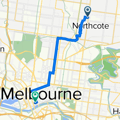
A cycling route starting in Northcote, Victoria, Australia.
Overview
About this route
- -:--
- Duration
- 13.8 km
- Distance
- 65 m
- Ascent
- 101 m
- Descent
- ---
- Avg. speed
- ---
- Max. altitude

Route quality
Waytypes & surfaces along the route
Waytypes
Cycleway
8 km
(58 %)
Road
3.9 km
(28 %)
Surfaces
Paved
13.6 km
(99 %)
Unpaved
0 km
(<1 %)
Asphalt
8.6 km
(62 %)
Concrete
2.8 km
(20 %)
Route highlights
Points of interest along the route
Drinking water after 4.1 km
Beer stop (Bodriggy)
Drinking water after 8.7 km
Beer stop (Royston Hotel)
Drinking water after 9.1 km
Beer stop (Burnley Brewing)
Continue with Bikemap
Use, edit, or download this cycling route
You would like to ride tour de freedom or customize it for your own trip? Here is what you can do with this Bikemap route:
Free features
- Save this route as favorite or in collections
- Copy & plan your own version of this route
- Sync your route with Garmin or Wahoo
Premium features
Free trial for 3 days, or one-time payment. More about Bikemap Premium.
- Navigate this route on iOS & Android
- Export a GPX / KML file of this route
- Create your custom printout (try it for free)
- Download this route for offline navigation
Discover more Premium features.
Get Bikemap PremiumFrom our community
Other popular routes starting in Northcote
 Thornbury - Plenty - Thornbury circuit
- Distance
- 71.7 km
- Ascent
- 223 m
- Descent
- 223 m
- Location
- Northcote, Victoria, Australia
 Artiga Coffee, Ivanhoe Public Golf Course to Heidi MOMA
- Distance
- 14.4 km
- Ascent
- 153 m
- Descent
- 95 m
- Location
- Northcote, Victoria, Australia
 Canning Street to Work
- Distance
- 9.1 km
- Ascent
- 103 m
- Descent
- 108 m
- Location
- Northcote, Victoria, Australia
 tour de freedom
- Distance
- 13.8 km
- Ascent
- 65 m
- Descent
- 101 m
- Location
- Northcote, Victoria, Australia
 69 James St, Northcote to 5–11 Palmer Pde, Cremorne
- Distance
- 9.3 km
- Ascent
- 57 m
- Descent
- 93 m
- Location
- Northcote, Victoria, Australia
 northcote to camberwell junction
- Distance
- 11.2 km
- Ascent
- 122 m
- Descent
- 106 m
- Location
- Northcote, Victoria, Australia
 Merri Creek to Rubys and back on dirt side
- Distance
- 5.2 km
- Ascent
- 32 m
- Descent
- 34 m
- Location
- Northcote, Victoria, Australia
 Humevale
- Distance
- 92.1 km
- Ascent
- 558 m
- Descent
- 558 m
- Location
- Northcote, Victoria, Australia
Open it in the app