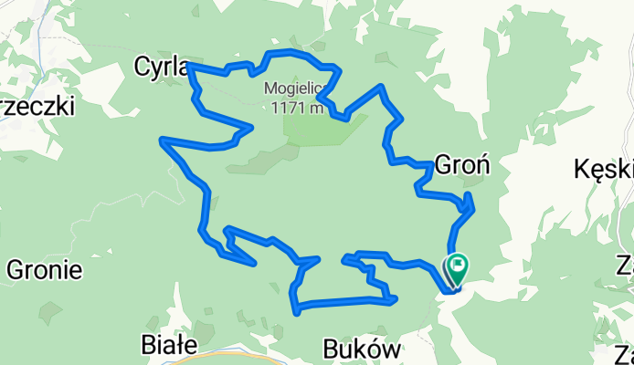
Wok贸艂 Mogielicy - light
A cycling route starting in S艂opnice, Lesser Poland Voivodeship, Poland.
Overview
About this route
- -:--
- Duration
- 22.5 km
- Distance
- 627 m
- Ascent
- 625 m
- Descent
- ---
- Avg. speed
- ---
- Max. altitude
Route quality
Waytypes & surfaces along the route
Waytypes
Access road
20 km
(89 %)
Track
1.6 km
(7 %)
Quiet road
0.9 km
(4 %)
Surfaces
Paved
8.3 km
(37 %)
Unpaved
14.2 km
(63 %)
Gravel
14.2 km
(63 %)
Paved (undefined)
6.7 km
(30 %)
Asphalt
1.6 km
(7 %)
Continue with Bikemap
Use, edit, or download this cycling route
You would like to ride Wok贸艂 Mogielicy - light or customize it for your own trip? Here is what you can do with this Bikemap route:
Free features
- Save this route as favorite or in collections
- Copy & plan your own version of this route
- Sync your route with Garmin or Wahoo
Premium features
Free trial for 3 days, or one-time payment. More about Bikemap Premium.
- Navigate this route on iOS & Android
- Export a GPX / KML file of this route
- Create your custom printout (try it for free)
- Download this route for offline navigation
Discover more Premium features.
Get Bikemap PremiumFrom our community
Other popular routes starting in S艂opnice
- 2017.02.11 UC FateBake - Pod艂opie艅
- Distance
- 28.1 km
- Ascent
- 726 m
- Descent
- 1,119 m
- Location
- S艂opnice, Lesser Poland Voivodeship, Poland
- wokol lopienia
- Distance
- 15.3 km
- Ascent
- 498 m
- Descent
- 498 m
- Location
- S艂opnice, Lesser Poland Voivodeship, Poland
- Wok贸艂 Mogielicy ze Stopnic
- Distance
- 49.5 km
- Ascent
- 1,260 m
- Descent
- 1,260 m
- Location
- S艂opnice, Lesser Poland Voivodeship, Poland
- Wok贸艂 Mogielicy - light
- Distance
- 22.5 km
- Ascent
- 627 m
- Descent
- 625 m
- Location
- S艂opnice, Lesser Poland Voivodeship, Poland
- Mogielica - petla
- Distance
- 44.2 km
- Ascent
- 1,047 m
- Descent
- 1,047 m
- Location
- S艂opnice, Lesser Poland Voivodeship, Poland
- Mogielica
- Distance
- 15.1 km
- Ascent
- 725 m
- Descent
- 725 m
- Location
- S艂opnice, Lesser Poland Voivodeship, Poland
- Okolice Limanowej
- Distance
- 316.8 km
- Ascent
- 4,516 m
- Descent
- 4,516 m
- Location
- S艂opnice, Lesser Poland Voivodeship, Poland
- Mogielica to nie wszystko
- Distance
- 25.1 km
- Ascent
- 1,004 m
- Descent
- 1,016 m
- Location
- S艂opnice, Lesser Poland Voivodeship, Poland
Open it in the app