

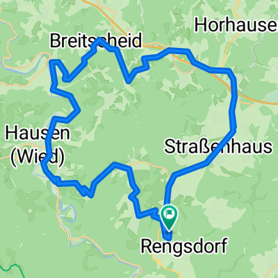
Rengsd-Völkerwiesenbach-Hardert-Aubach-Gierenderhöhe 25km
A cycling route starting in Rengsdorf, Rhineland-Palatinate, Germany.
Overview
About this route
Runde Rengsdorf-Völkerwiesenbach-Waldweg-Hardert-Aubachtal-Jahrsfeldermühlen-Niederraden-Oberraden-Gierenderhöhe-Oberhonnefeld-Straßenhaus-Bonefeld-Runde
- -:--
- Duration
- 24.7 km
- Distance
- 361 m
- Ascent
- 359 m
- Descent
- ---
- Avg. speed
- ---
- Avg. speed
Route quality
Waytypes & surfaces along the route
Waytypes
Track
13.1 km
(53 %)
Quiet road
5.4 km
(22 %)
Surfaces
Paved
13.4 km
(54 %)
Unpaved
9.4 km
(38 %)
Asphalt
12.2 km
(49 %)
Gravel
5.8 km
(23 %)
Continue with Bikemap
Use, edit, or download this cycling route
You would like to ride Rengsd-Völkerwiesenbach-Hardert-Aubach-Gierenderhöhe 25km or customize it for your own trip? Here is what you can do with this Bikemap route:
Free features
- Save this route as favorite or in collections
- Copy & plan your own version of this route
- Sync your route with Garmin or Wahoo
Premium features
Free trial for 3 days, or one-time payment. More about Bikemap Premium.
- Navigate this route on iOS & Android
- Export a GPX / KML file of this route
- Create your custom printout (try it for free)
- Download this route for offline navigation
Discover more Premium features.
Get Bikemap PremiumFrom our community
Other popular routes starting in Rengsdorf
 Rheinsteig Etappe 7 Rengsdorf - Sayn
- Distance
- 15.7 km
- Ascent
- 246 m
- Descent
- 430 m
- Location
- Rengsdorf, Rhineland-Palatinate, Germany
 Rengsd-Völkerwiesenbach-Hardert-Aubach-Gierenderhöhe 25km
- Distance
- 24.7 km
- Ascent
- 361 m
- Descent
- 359 m
- Location
- Rengsdorf, Rhineland-Palatinate, Germany
 Rengsdorf-Urbach-Runde 32 km
- Distance
- 32 km
- Ascent
- 432 m
- Descent
- 431 m
- Location
- Rengsdorf, Rhineland-Palatinate, Germany
 Dienstag ?
- Distance
- 47.6 km
- Ascent
- 518 m
- Descent
- 518 m
- Location
- Rengsdorf, Rhineland-Palatinate, Germany
 8-RWW-MTB-Tour
- Distance
- 34.5 km
- Ascent
- 494 m
- Descent
- 494 m
- Location
- Rengsdorf, Rhineland-Palatinate, Germany
 Rengsdorf Fockenbachtal
- Distance
- 31.1 km
- Ascent
- 447 m
- Descent
- 447 m
- Location
- Rengsdorf, Rhineland-Palatinate, Germany
 Kleine Rengsdorfer Runde
- Distance
- 30.6 km
- Ascent
- 545 m
- Descent
- 581 m
- Location
- Rengsdorf, Rhineland-Palatinate, Germany
 Rengsdorf, Kurtscheid, Wolfenacker, Elsbachtal, Willroth, Rengsdorf
- Distance
- 42.2 km
- Ascent
- 576 m
- Descent
- 576 m
- Location
- Rengsdorf, Rhineland-Palatinate, Germany
Open it in the app