

OBK Almtal (R11)-Laudachsee-Traunsee (R2)
A cycling route starting in Scharnstein, Upper Austria, Austria.
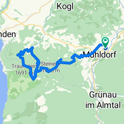
Overview
About this route
Zwischen Viechtwang und Scharnstein Abzweigung vom Almtalradweg R11. Bald geht's dahin im idylischem Laudachtal. Beim "Franz'l im Hoiz" kann man nun links hinunter und dann rechts über eine schöne Forststraße zum Laudachsee (Ziel 1) radeln oder (als Ziel 2) gleich rechts über die Laudachseestraße hinunter zur Talstation der Grünbergbahn den Traunsee erkunden. Dort ist auch gleich der Anschluß zum Salzkammergutradweg R2
- 54 min
- Duration
- 24.5 km
- Distance
- 741 m
- Ascent
- 353 m
- Descent
- 27 km/h
- Avg. speed
- ---
- Max. altitude

Route highlights
Points of interest along the route
Point of interest after 0 km
Kreuzung / Abzweigung R11 Almtalweg
Accommodation after 1.3 km
Parkplatz Taverne in der Than
Point of interest after 20.6 km
Gasthaus Franz'l im Holz
Continue with Bikemap
Use, edit, or download this cycling route
You would like to ride OBK Almtal (R11)-Laudachsee-Traunsee (R2) or customize it for your own trip? Here is what you can do with this Bikemap route:
Free features
- Save this route as favorite or in collections
- Copy & plan your own version of this route
- Sync your route with Garmin or Wahoo
Premium features
Free trial for 3 days, or one-time payment. More about Bikemap Premium.
- Navigate this route on iOS & Android
- Export a GPX / KML file of this route
- Create your custom printout (try it for free)
- Download this route for offline navigation
Discover more Premium features.
Get Bikemap PremiumFrom our community
Other popular routes starting in Scharnstein
 Hochsalm
- Distance
- 6.6 km
- Ascent
- 715 m
- Descent
- 15 m
- Location
- Scharnstein, Upper Austria, Austria
 laudachsee
- Distance
- 38.6 km
- Ascent
- 1,543 m
- Descent
- 1,544 m
- Location
- Scharnstein, Upper Austria, Austria
 Rundfahrt über Feichtenberg
- Distance
- 29 km
- Ascent
- 396 m
- Descent
- 393 m
- Location
- Scharnstein, Upper Austria, Austria
 Zum Almsee
- Distance
- 57.5 km
- Ascent
- 242 m
- Descent
- 242 m
- Location
- Scharnstein, Upper Austria, Austria
 Einfache Fahrt in Vorchdorf
- Distance
- 18.5 km
- Ascent
- 138 m
- Descent
- 194 m
- Location
- Scharnstein, Upper Austria, Austria
 von Scharnstein ins Almtal
- Distance
- 58.5 km
- Ascent
- 347 m
- Descent
- 353 m
- Location
- Scharnstein, Upper Austria, Austria
 Mühldorf nach Grünau im Altal
- Distance
- 20.7 km
- Ascent
- 266 m
- Descent
- 211 m
- Location
- Scharnstein, Upper Austria, Austria
 2023_06_26_Steineck
- Distance
- 42.9 km
- Ascent
- 1,219 m
- Descent
- 1,220 m
- Location
- Scharnstein, Upper Austria, Austria
Open it in the app