

caminho ponte das antas
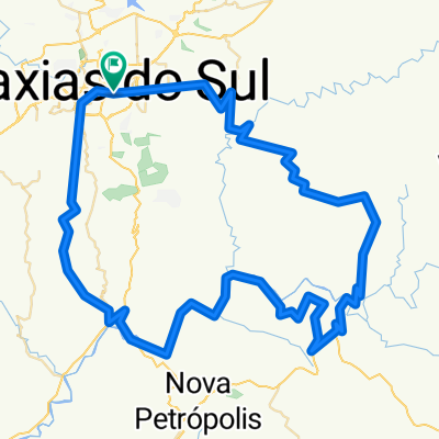
A cycling route starting in Caxias do Sul, Rio Grande do Sul, Brazil.
Overview
About this route
- -:--
- Duration
- 64.3 km
- Distance
- 530 m
- Ascent
- 1,033 m
- Descent
- ---
- Avg. speed
- ---
- Max. altitude
Route quality
Waytypes & surfaces along the route
Waytypes
Quiet road
39.9 km
(62 %)
Road
9 km
(14 %)
Surfaces
Paved
9 km
(14 %)
Unpaved
19.3 km
(30 %)
Unpaved (undefined)
18 km
(28 %)
Asphalt
7.7 km
(12 %)
Route highlights
Points of interest along the route
Point of interest after 48.5 km
inicio da descida 50 km
Continue with Bikemap
Use, edit, or download this cycling route
You would like to ride caminho ponte das antas or customize it for your own trip? Here is what you can do with this Bikemap route:
Free features
- Save this route as favorite or in collections
- Copy & plan your own version of this route
- Sync your route with Garmin or Wahoo
Premium features
Free trial for 3 days, or one-time payment. More about Bikemap Premium.
- Navigate this route on iOS & Android
- Export a GPX / KML file of this route
- Create your custom printout (try it for free)
- Download this route for offline navigation
Discover more Premium features.
Get Bikemap PremiumFrom our community
Other popular routes starting in Caxias do Sul
 Pedalada rumo a vovozinha!👵👵
- Distance
- 103.1 km
- Ascent
- 486 m
- Descent
- 1,208 m
- Location
- Caxias do Sul, Rio Grande do Sul, Brazil
 Caxias - Tubarão via serra do Corvo Branco
- Distance
- 361.4 km
- Ascent
- 1,998 m
- Descent
- 2,805 m
- Location
- Caxias do Sul, Rio Grande do Sul, Brazil
 Ana Rech/Fazenda Souza/Vila Seca/Faxinal
- Distance
- 38.5 km
- Ascent
- 677 m
- Descent
- 678 m
- Location
- Caxias do Sul, Rio Grande do Sul, Brazil
 Farroupilha-NovaSardemnha-Buratti-SaoPedro-Caravagio
- Distance
- 87.9 km
- Ascent
- 912 m
- Descent
- 938 m
- Location
- Caxias do Sul, Rio Grande do Sul, Brazil
 FazSouza-SaoRoque-Presidio-Marrecas-VSeca-Faxinal-ARech
- Distance
- 94.6 km
- Ascent
- 1,002 m
- Descent
- 1,002 m
- Location
- Caxias do Sul, Rio Grande do Sul, Brazil
 LGonçalvesDias-LBrasil-SãoMaximiliano-SantaLúcia
- Distance
- 107.5 km
- Ascent
- 1,896 m
- Descent
- 1,896 m
- Location
- Caxias do Sul, Rio Grande do Sul, Brazil
 Caxias-Flores-NPadua-NRoma-Bento-Jansen
- Distance
- 120.1 km
- Ascent
- 1,479 m
- Descent
- 1,480 m
- Location
- Caxias do Sul, Rio Grande do Sul, Brazil
 Caminhada lenta Brasil
- Distance
- 11.5 km
- Ascent
- 969 m
- Descent
- 972 m
- Location
- Caxias do Sul, Rio Grande do Sul, Brazil
Open it in the app