

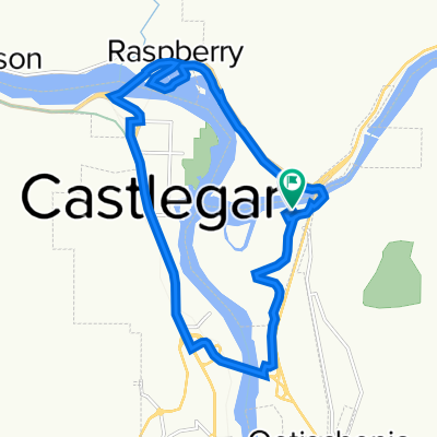
Castlegar to Chrisitina Lake
A cycling route starting in Castlegar, British Columbia, Canada.
Overview
About this route
Castlegar to Chrisitina Lake rail trail
- -:--
- Duration
- 86.4 km
- Distance
- 898 m
- Ascent
- 823 m
- Descent
- ---
- Avg. speed
- ---
- Max. altitude

Route quality
Waytypes & surfaces along the route
Waytypes
Track
77.7 km
(90 %)
Road
6.9 km
(8 %)
Surfaces
Unpaved
77.7 km
(90 %)
Unpaved (undefined)
76.9 km
(89 %)
Gravel
0.9 km
(1 %)
Undefined
8.6 km
(10 %)
Continue with Bikemap
Use, edit, or download this cycling route
You would like to ride Castlegar to Chrisitina Lake or customize it for your own trip? Here is what you can do with this Bikemap route:
Free features
- Save this route as favorite or in collections
- Copy & plan your own version of this route
- Split it into stages to create a multi-day tour
- Sync your route with Garmin or Wahoo
Premium features
Free trial for 3 days, or one-time payment. More about Bikemap Premium.
- Navigate this route on iOS & Android
- Export a GPX / KML file of this route
- Create your custom printout (try it for free)
- Download this route for offline navigation
Discover more Premium features.
Get Bikemap PremiumFrom our community
Other popular routes starting in Castlegar
 Barry Rd, Central Kootenay to Barry Rd, Central Kootenay
- Distance
- 14.7 km
- Ascent
- 197 m
- Descent
- 195 m
- Location
- Castlegar, British Columbia, Canada
 Castlegar to Chrisitina Lake
- Distance
- 86.4 km
- Ascent
- 898 m
- Descent
- 823 m
- Location
- Castlegar, British Columbia, Canada
 RRday3Option2
- Distance
- 122.9 km
- Ascent
- 2,440 m
- Descent
- 1,879 m
- Location
- Castlegar, British Columbia, Canada
 TCT Sectional/ Castlegar to Trail CLONED FROM ROUTE 552026
- Distance
- 35.6 km
- Ascent
- 368 m
- Descent
- 390 m
- Location
- Castlegar, British Columbia, Canada
 Castelgar-Gladstone provincial park
- Distance
- 70.4 km
- Ascent
- 1,169 m
- Descent
- 1,075 m
- Location
- Castlegar, British Columbia, Canada
 310 Columbia Ave, Castlegar to Robertson St, Trail
- Distance
- 33.8 km
- Ascent
- 471 m
- Descent
- 488 m
- Location
- Castlegar, British Columbia, Canada
 2018-02: Castlegar to Christina Lake
- Distance
- 88.8 km
- Ascent
- 987 m
- Descent
- 1,001 m
- Location
- Castlegar, British Columbia, Canada
 caslegar exploring
- Distance
- 10.7 km
- Ascent
- 74 m
- Descent
- 101 m
- Location
- Castlegar, British Columbia, Canada
Open it in the app