

laredo, ampuero, samano, castro, Laredo
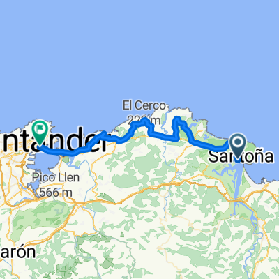
A cycling route starting in Santoña, Cantabria, Spain.
Overview
About this route
The next stage takes place on the road. The pavement is in good condition. On the N634 there is hardly any traffic, whereas on the N629 it is necessary to use the shoulder well as it is a fast lane, from Colindres to Ampuero. In Limpias we can take the N629a road and we will travel much more calmly.
It is a route with several climbs, the most notable are Hoyomenor and La Granja, the first two. Once past Castro, there is the climb of Pontarrón towards Liendo and the climb to Tarrueza, which if you arrive just out of energy, will feel long.
Sorry for not providing more information, but this is the first route I am posting.
- -:--
- Duration
- 75 km
- Distance
- 1,049 m
- Ascent
- 1,052 m
- Descent
- ---
- Avg. speed
- ---
- Max. altitude
Route quality
Waytypes & surfaces along the route
Waytypes
Cycleway
26.2 km
(35 %)
Road
24.7 km
(33 %)
Surfaces
Paved
23.2 km
(31 %)
Unpaved
1.5 km
(2 %)
Asphalt
23.2 km
(31 %)
Gravel
0.7 km
(1 %)
Continue with Bikemap
Use, edit, or download this cycling route
You would like to ride laredo, ampuero, samano, castro, Laredo or customize it for your own trip? Here is what you can do with this Bikemap route:
Free features
- Save this route as favorite or in collections
- Copy & plan your own version of this route
- Sync your route with Garmin or Wahoo
Premium features
Free trial for 3 days, or one-time payment. More about Bikemap Premium.
- Navigate this route on iOS & Android
- Export a GPX / KML file of this route
- Create your custom printout (try it for free)
- Download this route for offline navigation
Discover more Premium features.
Get Bikemap PremiumFrom our community
Other popular routes starting in Santoña
 Recording from 24 augustus 13:35
- Distance
- 10.9 km
- Ascent
- 552 m
- Descent
- 550 m
- Location
- Santoña, Cantabria, Spain
 Jakobsweg Etappe 15 Santona - Unquera
- Distance
- 100 km
- Ascent
- 785 m
- Descent
- 787 m
- Location
- Santoña, Cantabria, Spain
 Santoña - Santander
- Distance
- 43.1 km
- Ascent
- 286 m
- Descent
- 284 m
- Location
- Santoña, Cantabria, Spain
 repe
repe- Distance
- 76.4 km
- Ascent
- 659 m
- Descent
- 659 m
- Location
- Santoña, Cantabria, Spain
 Paseo rápido en Santoña
- Distance
- 10.5 km
- Ascent
- 44 m
- Descent
- 44 m
- Location
- Santoña, Cantabria, Spain
 Tomarrabaketak 3.2
- Distance
- 61.5 km
- Ascent
- 410 m
- Descent
- 414 m
- Location
- Santoña, Cantabria, Spain
 Tomarrabaketal 3.1
- Distance
- 55 km
- Ascent
- 411 m
- Descent
- 416 m
- Location
- Santoña, Cantabria, Spain
 Ruta Garzon
- Distance
- 77 km
- Ascent
- 763 m
- Descent
- 708 m
- Location
- Santoña, Cantabria, Spain
Open it in the app