

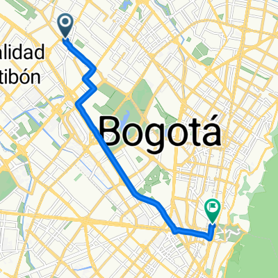
De Diagonal 48 Sur 51-44, Bogotá a Calle 27 Sur 13-06, Bogotá
A cycling route starting in Bogotá, Bogota D.C., Colombia.
Overview
About this route
- 17 min
- Duration
- 5.2 km
- Distance
- 38 m
- Ascent
- 27 m
- Descent
- 18 km/h
- Avg. speed
- ---
- Max. altitude

Route quality
Waytypes & surfaces along the route
Waytypes
Quiet road
2.7 km
(52 %)
Busy road
1 km
(19 %)
Surfaces
Paved
4.1 km
(79 %)
Asphalt
4 km
(78 %)
Concrete
0.1 km
(1 %)
Undefined
1.1 km
(21 %)
Continue with Bikemap
Use, edit, or download this cycling route
You would like to ride De Diagonal 48 Sur 51-44, Bogotá a Calle 27 Sur 13-06, Bogotá or customize it for your own trip? Here is what you can do with this Bikemap route:
Free features
- Save this route as favorite or in collections
- Copy & plan your own version of this route
- Sync your route with Garmin or Wahoo
Premium features
Free trial for 3 days, or one-time payment. More about Bikemap Premium.
- Navigate this route on iOS & Android
- Export a GPX / KML file of this route
- Create your custom printout (try it for free)
- Download this route for offline navigation
Discover more Premium features.
Get Bikemap PremiumFrom our community
Other popular routes starting in Bogotá
 bike tour through Tunjuelito
- Distance
- 34.4 km
- Ascent
- 976 m
- Descent
- 978 m
- Location
- Bogotá, Bogota D.C., Colombia
 Bogota - Viota - Girardot- Ibague - Toche - Salento
- Distance
- 358.9 km
- Ascent
- 3,835 m
- Descent
- 4,515 m
- Location
- Bogotá, Bogota D.C., Colombia
 Salto Tequendama
- Distance
- 22.1 km
- Ascent
- 72 m
- Descent
- 354 m
- Location
- Bogotá, Bogota D.C., Colombia
 Calle 42, Bogotá a Avenida Calle 134, Bogotá
- Distance
- 13.3 km
- Ascent
- 132 m
- Descent
- 137 m
- Location
- Bogotá, Bogota D.C., Colombia
 Colombia 🇨🇴 2019
- Distance
- 3,305.3 km
- Ascent
- 8,902 m
- Descent
- 8,902 m
- Location
- Bogotá, Bogota D.C., Colombia
 De Carrera 53d # 4C-30, Bogotá, D.C. a Calle 5a # 53D-35, Bogotá, D.C.
- Distance
- 54.2 km
- Ascent
- 1,304 m
- Descent
- 1,328 m
- Location
- Bogotá, Bogota D.C., Colombia
 Salida a La Calera
- Distance
- 64.6 km
- Ascent
- 837 m
- Descent
- 840 m
- Location
- Bogotá, Bogota D.C., Colombia
 Calle 63B, Bogotá a Calle 38, Bogotá
- Distance
- 10.7 km
- Ascent
- 50 m
- Descent
- 12 m
- Location
- Bogotá, Bogota D.C., Colombia
Open it in the app