

EM - Kandel -EM
A cycling route starting in Emmendingen, Baden-Wurttemberg, Germany.
Overview
About this route
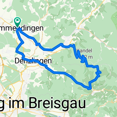
Eine Tour von Emmendingen über Walkirch hoch auf das Dach der Regio - den Kandel. Der Anstieg hat es in sich! In einer rasanten Abfahrt geht es durch das Glottertal runter nach Denzlingen und dann wieder zurück nach Emmendingen. Kleiner Tipp: nur an warmen Tagen bzw. bei schönem Wetter fahren. Oben auf dem Kandel (1.241 m) ist es oft richtig frisch. Oder eben warme Kleidung für die Abfahrt einpacken.
- -:--
- Duration
- 54.4 km
- Distance
- 994 m
- Ascent
- 994 m
- Descent
- ---
- Avg. speed
- ---
- Max. altitude
Continue with Bikemap
Use, edit, or download this cycling route
You would like to ride EM - Kandel -EM or customize it for your own trip? Here is what you can do with this Bikemap route:
Free features
- Save this route as favorite or in collections
- Copy & plan your own version of this route
- Sync your route with Garmin or Wahoo
Premium features
Free trial for 3 days, or one-time payment. More about Bikemap Premium.
- Navigate this route on iOS & Android
- Export a GPX / KML file of this route
- Create your custom printout (try it for free)
- Download this route for offline navigation
Discover more Premium features.
Get Bikemap PremiumFrom our community
Other popular routes starting in Emmendingen
 EM Waldkirch Gescheit Freiamt
- Distance
- 46.2 km
- Ascent
- 462 m
- Descent
- 464 m
- Location
- Emmendingen, Baden-Wurttemberg, Germany
 EM rund um Freiamt
- Distance
- 39.6 km
- Ascent
- 728 m
- Descent
- 728 m
- Location
- Emmendingen, Baden-Wurttemberg, Germany
 Landkreis EM (EM-Kaiserstuhl-March-Freiamt-EM)
- Distance
- 74.4 km
- Ascent
- 647 m
- Descent
- 564 m
- Location
- Emmendingen, Baden-Wurttemberg, Germany
 Emmendingen an der Elz bis nach Buchholz, Denzlingen Reute und zurück
- Distance
- 22.5 km
- Ascent
- 70 m
- Descent
- 72 m
- Location
- Emmendingen, Baden-Wurttemberg, Germany
 Emmendingen-Freiamt
- Distance
- 43.4 km
- Ascent
- 337 m
- Descent
- 337 m
- Location
- Emmendingen, Baden-Wurttemberg, Germany
 Test Emmendingen
- Distance
- 2.7 km
- Ascent
- 0 m
- Descent
- 8 m
- Location
- Emmendingen, Baden-Wurttemberg, Germany
 EM-Hünersedel
- Distance
- 50.6 km
- Ascent
- 848 m
- Descent
- 846 m
- Location
- Emmendingen, Baden-Wurttemberg, Germany
 EM - Kandel -EM
- Distance
- 54.4 km
- Ascent
- 994 m
- Descent
- 994 m
- Location
- Emmendingen, Baden-Wurttemberg, Germany
Open it in the app