

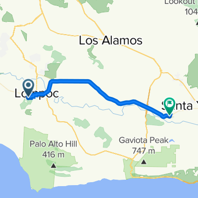
044 panamericana
A cycling route starting in Lompoc, California, United States.
Overview
About this route
lompoc-santa rosa rd.-buellton-solvang-quiota creek-lake cachuma-san marcos pass-santa barbara-summerland-carpinteria-lake casitas
- -:--
- Duration
- 143.4 km
- Distance
- 1,173 m
- Ascent
- 1,044 m
- Descent
- ---
- Avg. speed
- ---
- Max. altitude
Continue with Bikemap
Use, edit, or download this cycling route
You would like to ride 044 panamericana or customize it for your own trip? Here is what you can do with this Bikemap route:
Free features
- Save this route as favorite or in collections
- Copy & plan your own version of this route
- Split it into stages to create a multi-day tour
- Sync your route with Garmin or Wahoo
Premium features
Free trial for 3 days, or one-time payment. More about Bikemap Premium.
- Navigate this route on iOS & Android
- Export a GPX / KML file of this route
- Create your custom printout (try it for free)
- Download this route for offline navigation
Discover more Premium features.
Get Bikemap PremiumFrom our community
Other popular routes starting in Lompoc
 Lompoc - Santa Barbara
- Distance
- 86.4 km
- Ascent
- 471 m
- Descent
- 498 m
- Location
- Lompoc, California, United States
 SF to LA Day 6 82 miles
- Distance
- 132 km
- Ascent
- 500 m
- Descent
- 530 m
- Location
- Lompoc, California, United States
 ALC9 - Day 6 Lompoc to Ventura
- Distance
- 142.6 km
- Ascent
- 574 m
- Descent
- 603 m
- Location
- Lompoc, California, United States
 523 S X St, Lompoc to 1760 Mission Dr, Solvang
- Distance
- 36.8 km
- Ascent
- 284 m
- Descent
- 178 m
- Location
- Lompoc, California, United States
 523 S X St, Lompoc to 1760 Mission Dr, Solvang
- Distance
- 36.8 km
- Ascent
- 284 m
- Descent
- 178 m
- Location
- Lompoc, California, United States
 044 panamericana
- Distance
- 143.4 km
- Ascent
- 1,173 m
- Descent
- 1,044 m
- Location
- Lompoc, California, United States
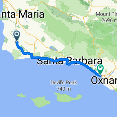
 7. P.C.H Lompoc Oxnard
- Distance
- 163.4 km
- Ascent
- 584 m
- Descent
- 614 m
- Location
- Lompoc, California, United States
 Howards bd run part 2
- Distance
- 36.7 km
- Ascent
- 207 m
- Descent
- 210 m
- Location
- Lompoc, California, United States
Open it in the app